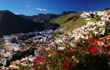
If you are looking for peace and solitude during your holidays, and want to combine the whole thing with wonderful summer weather and originality, the Cycladic island of Amorgos is the right place for you. There are neither large hotels nor other traces of mass tourism here. Less than 2,000 people live on the island, which is around 38 square kilometres in size. On the other hand, there are breathtakingly beautiful cliffs, rock monasteries worth seeing and fascinating hiking routes on well-trodden mule tracks.
Amorgos can be reached by ferry from the Greek capital Athens, or from one of the larger Cyclades islands. Even the entrance over the emerald shimmering Aegean Sea is an experience. The ferries land alternately in Katapola and Ägiali. During the arrival of the ferries in Katapola, visitors have a fantastic view of the surrounding cliffs with their bizarre rock formations. Afterwards, it is worth stopping in the traditional fishing village. Directly by the sea, there are excellent restaurants where the fresh catch of the fishermen is tastily prepared and offered for sale. From the terraces of the restaurants, you can watch a tranquil sunset in the evening. The small village is winding, visitors stroll through enchanted and narrow alleys. The houses have been built, as on the rest of the island, entirely according to the Cycladic architectural style. Box-shaped snow-white houses, with blue decorations that can be seen occasionally, are lined up next to each other. After strolling through the village, a short hike should be taken to the excavation site of the ancient city of Minoa, which is located about three kilometers from the center of Katapola. A well-signposted hiking trail leads there. Minoa is located above the modern village. In addition to the exciting remains of a long-abandoned city, there is also a magnificent view over the bay of Katapola to enjoy.
A stroll through the idyllic island capital of Chora
Another highlight is a visit to the island’s capital Chora, which is sometimes referred to as Hora. The maze of alleys is even more convoluted here than in Katapola. In Chora, there is also a Venetian-style fortress that dates back to the 13th century. It is located high on a rock above the city. The best way to climb the fortress is in the evening hours, because then you can marvel at the setting sun in addition to the wide panoramic view over Chora. In the archaeological museum of Chora, which is open to all visitors, excavation finds from the island of Amorgos from the Minoan era are exhibited. A short walk east takes the adventurous to some traditional stone windmills.
The new Aegean crime novel by Peter Pachel promises you even more exciting experiences on holiday on Amorgos.
Content: A pensioner is found dead in an old apartment in Berlin Charlottenburg. He was brutally murdered, and the circumstances of his death horrify even hardened detectives. The first clues lead to a small coastal town on an island in the southern Aegean. Filippos Panos, the police chief of Paros, is ordered to Amorgos to support the German-Greek team of investigators. What did the old man want there shortly before his death, after he had turned his back on the island many years ago? It quickly becomes clear that he was not only on the island for his vacation, and long-forgotten things become the focus of the investigation …
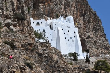
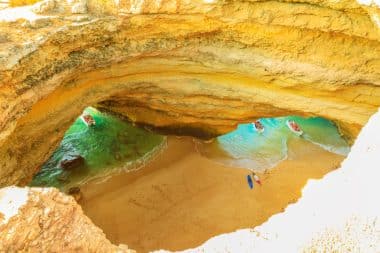
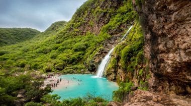
On foot, over the Palia Strata to the Orthodox monastery of Panagia Chozoviotissa
View of the monastery of Panagia Chozoviotissa, Image: John Ilio / shutterstock
Palia Strata literally translates to “Old Road”. This trail, which is the most famous and also the most beautiful on the whole island, is an old mule track. From Chora, you hike over 14.5 kilometers to the Orthodox monastery of Panagia Chozoviotissa, which is known as the landmark of the island of Amorgos. The monastery complex, which stands on a 300-metre-high cliff, was built as early as the 11th century. The monastery of Panagia Chozoviotissa is not only ancient, but even the second oldest monastery in all of Greece. There are 300 steeply rising steps leading to the entrance of the monastery, which makes the ascent very sweaty on hot days. On the other hand, the view over Chora from the monastery is phenomenal.
If you want to visit the monastery not only from the outside, but also from the inside, which is free of charge, you should adhere to the strict dress code of the Orthodox monks. Men and women must wear long trousers. For men these are long trousers, for women skirts. Ladies who are not skirt wearers, for example, can improvise with a long scarf that they wrap around their hips. In addition, the shoulders must be covered when entering the monastery. Afterwards we continue via Kapsala to the villages of Asfondilitis, Potamos and Aegiali. The hiking trail, like many hiking routes on the island, is considered difficult. The climbs are sometimes very steep. The ground often consists of narrow paths covered with scree. It is therefore advisable to wear good hiking shoes in any case. Depending on the season, it can also get very hot on the hike. Therefore, you should always take enough water with you. A hat and sunscreen should also be taken with you on the hiking tour.
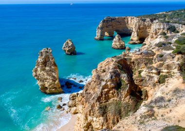
The most beautiful beaches in Amorgos
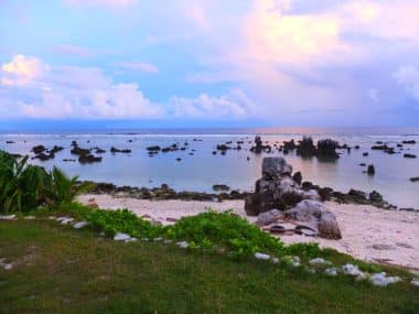
The Cycladic island of Amorgos is not necessarily known as a classic beach holiday destination due to its many cliffs. But even here there are some beach pearls that are worth visiting. The beaches of Psili Ammos, Levrossos and Hochlakies are all hidden at the end of a narrow hiking trail. They can also be reached by boat from the water. Ideal for sun worshippers who love to be alone.
Mexico, the southern neighbor of the USA, is the largest Spanish-speaking country in the world in terms of population. Geographically, it belongs to North America. Mexico is about 10 – 12 hours away from Germany by plane.
Most of Mexico’s residents speak Spanish. In addition, dozens of native languages are spoken. English is not understood or spoken everywhere. Because the country is very mountainous, there are large differences in the local climate. In addition to desert climates, especially in the north, there are large regions with alpine, subtropical and tropical climates. The UV radiation is very intense and the climate is generally warm and sunny. Travellers should therefore take appropriate precautions. The area of today’s Mexico was already inhabited in prehistoric times. The most famous peoples who lived there before the arrival of the Spaniards were the Olmecs, Toltecs, Mayans and Aztecs. Due to its long history, Mexico is rich in historical buildings and sights.
The most beautiful vacation spots in Mexico
One thing should be clear to every visitor to Mexico: with such a wide variety of landscapes and cultures, it is impossible to see everything. Tourists are forced to make a choice.
The Yucatan Peninsula
The Sian Ka’an Laguna in Yucatan, Image: Gimas / shutterstock
The peninsula in southeastern Mexico is at the top of the scale of popularity. There are several reasons for this. The city of Cancun has an important international airport, which is also served by flights from Germany . Yucatan is characterized by its tropical climate and beautiful landscapes. It is located in the Caribbean Sea and has some of the most beautiful beaches in the world. The region is nicknamed the Riviera Maya for a reason. Not far from the beach, lush tropical jungle is waiting to be explored. In the beautiful city of Merida, guests feel transported back to the Spanish colonial era. If you don’t just want to lie on the beach or swim, you can explore numerous Mayan ruins in the jungle. Yucatan has the great advantage that many sights are concentrated in a relatively small area. A variety of activities are possible, from beach vacations to diving and surfing on some of the best beaches in the world to adventurous expeditions to long-abandoned Mayan cities that make you feel a bit like Indiana Jones.
Playa del Carmen
The place is one of the most popular destinations in Mexico. Playa del Carmen is located about halfway between Cancun and Tulum. Playa, as the city is called by its approximately 250,000 inhabitants, is particularly popular with German holidaymakers because it can be easily reached by bus via Cancun International Airport. In contrast to other seaside resorts, Playa del Carmen has retained much of its original flair. The beautiful beach, for example, is not lined with huge hotel towers. The place is ideal for travelers who are planning a pure beach vacation and just want to swim and relax. Since Playa del Carmen is a large city, there are also good shopping facilities and many restaurants with Mexican and international cuisine. Most of the bathers in Playa del Carmen are Europeans. Americans prefer Cancun.
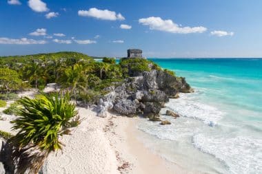
Tulum
Fantastic beach in Tulum, Image: andrmoel / shutterstock
Tulum is another well-known beach resort on the southern part of the Riviera Maya. The place is characterized by a lot of sunshine, tropical temperatures. The landscape is as beautiful as a photo in a travel brochure. The sea is azure, the sand is white, and the coast is lined with dark green palm trees. Very close to the modern city of Tulum are the ruins of the Mayan city of the same name, a visit to which is an essential part of a stay. Inland, cenotes (caves with fresh water) are waiting to be explored. If the sea water is too warm for you, you can refresh yourself in the clear and cool fresh water. Dives are also offered under guidance. Not far from Tulum is the Sian Kaan National Park, where you can watch coatis, iguanas, turtles and dolphins.
Cozumel
The Mexican island of Cozumel, Image: lunamarina / shutterstock
If you want to experience a real Caribbean feeling, you should book a stay on the island of Cozumel . It is the easternmost point of Mexico and is one of the dream destinations in the world. The main town, San Miguel de Cozumel, is full of lively life and offers plenty of culture. However, most of the island is hardly populated. There, visitors can relax in untouched nature. The east coast in particular is almost unpopulated. Not only bathers, but also divers and snorkelers feel like they’re in paradise on Cozumel . The coral reefs off the coast are considered by connoisseurs to be among the best diving areas in the world.
The Pacific Coast
This region of Mexico is characterized by its tropical climate. It stretches over several of the 31 Mexican states and is also called the Mexican Riviera. Many of the beaches have strong surf, which makes them very popular with surfers. The weather will be mostly sunny. There are no hurricanes like in the Caribbean. The most famous is probably the seaside resort of Acapulco . Guadalajara, the second largest city in Mexico, is located inland. The region is known for its many historical sights and good cuisine. From this region come such typical Mexican cultural assets as tequila and mariachi music.
Central Mexico
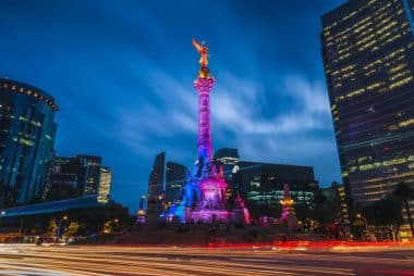
The El Ángel de la Independencia in Mexico City, Image: Vincent St. Thomas / shutterstock
In the center of the region is Mexico City, the capital and largest city of the country as well as the main international airport. Mexico City has a lot to offer in terms of culture. For tourists, the world-famous ruined city of Teotihuacan with its mighty pyramids should be of particular interest. The cities of Puebla and Veracruz with their colonial architecture are also worth seeing. Central Mexico is a highland characterized by vast plains and mighty volcanoes. Mexico City, for example, is more than 2,000 meters above sea level.
Baja California
The elongated narrow peninsula is located in western Mexico and stretches over a distance of more than 1,200 km from the far north in Tijuana, the border city to the USA, to San José del Cabo at the southern tip. Baja California is characterized by a desert climate. The region has retained much of its originality and, with a few exceptions (including Los Cabos in the south), is hardly touched by mass tourism. The beaches are mostly lonely. Every year from December to April, you can watch the impressive natural spectacle of the whale migration there.
If visitors follow a few simple rules of conduct, nothing stands in the way of a relaxing vacation in Mexico. The hotel staff will be happy to advise and give useful tips.
The Algarve is by far the most popular holiday region in Portugal in the German-speaking world. When you think of Portugal, you often think of the picturesque beaches, romantic fishing villages and rugged cliffs. And indeed, the Algarve keeps its promises. The more than 200-kilometre-long coastline attracts tourists with its sandy beaches and fascinating flora and fauna. But athletes are not neglected here either, because the rough sea is known for its great opportunities for surfing and sailing.
The southernmost region of Portugal has everything you need for a special and varied holiday. Above all, this variety is unique. In the port city of Lagos, those interested in culture will find their first port of call. The historic old town is unique and the Fort Ponta da Bandeira is definitely worth a visit. Of course, the capital of the region, Faro, is also exciting for holidaymakers. Here, the influence of the Romans in Portugal is particularly visible. A tour along the historic promenade and a detour to the bishop’s palace Paco Episcopal or the baroque city palace Solar do Capitao-Mor is a must. So after you have arrived, it is time to discover the many great offers of the region.
Surfing and sunbathing in the Algarve
If you are looking for adventure, you will also find it in the Algarve. On the rugged west coast of the Atlantic, surfers will find the perfect waves, almost 365 days a year. The first hotspot is the Praia de Odeceixe Mar near the small village of Odeceixe. Located near a nature reserve, surfers will find the best conditions here. A little further south is the popular beach of Carrapateira. Especially in the early morning hours, the panorama is fantastic.
For sun worshippers, there are fantastic beaches to discover along the entire south coast. No matter in which direction, you can hardly miss the many hidden bays and beaches. For example, the bay of Praia da Marinha and Praia do Tonel are particularly beautiful. One of the most famous and beautiful beaches is Praia da Marinha near Caramujeira. Once you’ve been here, you’ll have a hard time being impressed by other beaches. In contrast to other coastal regions, the Algarve manages to appear largely untouched and wild despite an enormous amount of tourism.
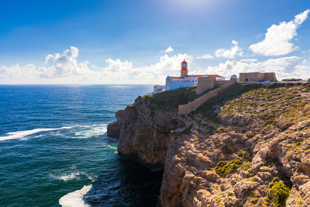
Fantastic nature and exciting sights
Cabo de São Vicente, Image: DaLiu / shutterstock
The most beautiful sights of the Algarve are actually of natural origin. Especially the many unique caves and grottoes are fascinating to discover. The most visited place in the region is Cape Cabo de São Vicente, with its small lighthouse in the middle of the cliffs. The cape is the southwesternmost point of the European continent and was considered the end of the world for people for a long time. Also highly recommended is the cave of Benagil.
But the Algarve is also not stingy with man-made sights. The city of Sagres, for example, offers plenty of room to lose track of time, with a historic fortress and its famous port. The cities of Lagos, Odeceixe and Aljezur should also be on the agenda of every visitor. This is where Portugal’s long history becomes visible. For those interested in architecture, the Algarve has many sights such as small and large churches and picturesque old towns. Especially in Lagos there are many sights such as the church of Santa Maria, a famous fortress and a spectacular zoo for the little ones. In the bone chapel of Faro, on the other hand, it gets morbid, because here over 1200 real skulls have been built into a 24 square meter chapel.
The Algarve – one of the most beautiful regions in Europe
The Algarve is one of the most popular destinations in Europe for a reason. Sun, great sandy beaches, the wild Atlantic Ocean or historic old towns – the region offers the right activity for every holidaymaker. Surfers ride along the west coast in search of the perfect wave, while families with children ride from one beach to another, soaking up the sun and discovering regional delicacies.
In the hinterland of the Algarve, an almost untouched nature is waiting to be discovered. The enormous variety and flora and fauna amaze everyone.
The Algarve is not particularly large: Around 440,000 inhabitants live on just under 5,000 square kilometres (for comparison, North Rhine-Westphalia has over 34,000 square kilometres). All the more astonishing how much variety can be found in such a small area. And that’s what makes the Algarve so special: endless different experiences in such a small space offer the opportunity to experience a practically new holiday every day – and practically on your doorstep.
The most beautiful sights in the Algarve
1. LagosThe port town of Lagos, Image: Steve Photography / shutterstock
The picturesque harbour town of Lagos has numerous fabulous hotspots in store, especially for visitors interested in history: The Castelo Dos Governadores, built by the Moors, is probably the most impressive part of the old city walls. The church Igreja de Santo Antonio with its sensational baroque interior, museums, the first slave market in Europe and port facilities are among the most important sights of Lagos. They are reminiscent of the time when Portugal was still an important royal shipping power and seafarers began their famous circumnavigations westwards from Lagos in the 15th century. And for a relaxing beach stay, the much-praised Praia de Dona Ana, surrounded by spectacular orange cliffs, offers a magical ambience for an unforgettable break.
2. Ponta da PiedadePonta da Piedade in Portugal, Image: artem evdokimov / shutterstock
Undoubtedly, one of the most beautiful natural highlights of the Algarve is located about 2.5 km south of Lagos. The famous Ponta Da Piedade rock structure on the coast offers a stunning sight with its colorful sandstone cliffs. The bizarre rock formations in the rocky Algarve form an idyllic protective bay with crystal clear turquoise waters that are perfect for swimming, diving and paddling.
3. Algar de BenagilAlgar de Benadil, Image: Benny Marty / shuttersto
An absolute must on the journey through the Algarve is the fascinating Benagil Cave with its dome-shaped dome open to the sky, a much visited hotspot on the beach Praia de Benagil near the coastal town of Portimao. In principle, access to the cave is only possible from the sea, so swimming or paddling is the order of the day to experience one of the truly overwhelming natural highlights on the Portuguese coast up close.
4. Hiking routes Discover the fabulous hiking routes through the picturesque landscapes of the Algarve! The impressive Vilamoura Natural Trail, west of Faro, passes through the protected Vilamoura Environmental Park. On a route of 5 km, nature lovers can discover the unique biodiversity of the region and observe rare birds such as ospreys, black storks or little terns. Enjoy a monumental coastal landscape along the cliff hiking trails from Senhora Da Rocha to Praia Da Marinha, exploring beautiful bays, small coastal settlements and fascinating flora and fauna! The view over the wide sea is simply breathtaking!
5. Praia da Marinha Praia da Marinha, Image: Luis_Mendes / shutterstock
At the end of this hiking tour and not far from the spectacular Benagil Cave, the world-famous Praia Da Marinha beach awaits you. Here, visitors can relax on the golden sandy beach and explore a magical underwater world while swimming and diving in the incredibly clear waters. The double sandstone rock arches at the western end of the beach stretch gallantly over the sea water, offering an exquisite sight and giving this part of the coastal landscape an unparalleled rugged charm.
6. Silves and the Castelo de Silves The interior of the Algarve introduces visitors to the typical southern Portuguese flair of this unique region. To the north and not far from Praia de Marinha, the medieval fortress Castelo de Silves towers over the town of Silves with its brick-red walls and towers. From the sandstone Moorish castle, various rulers ruled over the former independent small kingdom of Silves in the Middle Ages. The picturesque town attracts visitors from near and far with its authentic Algarve atmosphere and is definitely worth a visit.
7. FaroFaro, capital of the Algarve, Image: Robin Runck / shutterstock
Directly at the southernmost tip of the country is the capital of the Algarve, the famous port city of Faro. Surrounded by ancient Roman city walls, the old town is a real magnet and delights tourists with such exquisite buildings as the Bishop’s Palace, the City Hall and fascinating churches. A leisurely walk through the narrow winding streets, past colourful shops and souvenir shops along the pedestrian zone, allows visitors to experience the cosmopolitan flair of this traditional vibrant city and to enjoy and relax in the traditional taverns or restaurants typical of the country.
The port area of Faro is particularly interesting and surrounded by a protected lagoon. It is also home to the famous Museo Maritimo. Cape Cabo de Santa Maria is the southernmost point of Portugal and is located on the offshore island of Ilha da Barreta, a nature reserve of the Parque Natural da Ria Formosa. These and other small islands are easily accessible from Faro.
8. Olhão A visit to the old town of Olhão, which is characterized by an oriental-African flair, reveals the numerous architectural peculiarities of the place, which reflect a significant Arab influence. The hustle and bustle of the fish market exerts a magical appeal on tourists and forms a fantastic backdrop for unique photographs and impressions that immortalize the vital dynamism, intrinsic mood and traditional atmosphere of these authentic port and street scenes of Olhão.
9. TaviraRomanesque bridge in Tavira, Image: anyaivanova / shutterstock
Tavira, the exclusive coastal town in the east of the Algarve, is surrounded by enchanting sandy beaches and is famous for its very own charm. The popular holiday destination is a place steeped in history, where trade and fishing once flourished, and whose magnificent architectural highlights, churches, squares and exquisite buildings with magnificent facades bear witness to a former era of economic prosperity and prosperity.
10. Dolphins and seabirds: exciting observation tours The perfect highlight on any Algarve trip is a boat trip of several hours past the island of Ria Formosa and out into the Atlantic Ocean to make exciting discoveries in search of dolphins and whales, sea turtles and seabirds. On board an official observation vessel and accompanied by an experienced naturalist guide, nature-loving tourists have the unique opportunity to get to know the marine habitat of these fascinating marine creatures.
Water parks in the Algarve In the spectacular water parks “Slide & Splash” as well as “Aqualand” and “Aqua Show”, families with children get their money’s worth. Water slides, rapids, inflatable boat slides and other great pool attractions as well as rides provide fun, exciting experiences and fantastic adventures that will delight young and old!
Holidays in Oman? In Salalah? Anyone who plays with this idea is certainly still one of the exotics among the common Western tourists. And this despite the fact that Oman, and especially the city of Salalah in the southwest of the Sultanate, has Caribbean-like beaches, excellent diving spots, natural wonders between palm trees and breathtaking UNESCO World Heritage Sites to offer. If you want to travel to Salalah, you can fly directly to the former capital of Oman, which has a population of about 375,000. In addition to a passport, a visa is required for entry, which can also be applied for online.
Salalah – The best time to travel for sea, beach and diving
Salalah is great for a beach holiday. If you are planning one, you can escape the German dirty winter here, because the best time to travel is between the months of November and March. Although temperatures are summery all year round, ranging from 25 to 40 degrees, the southern part of the Sultanate, where Salalah is located, can be hit by heavy rainfall from June to September. Then it is rainy season in this part of the country and beach holidays can fall through completely under certain circumstances.
The most beautiful beaches and diving areas
Salalah is located in the middle of the Indian Ocean. Many hotels here have their own sections of beach, each of which is only a few steps away from the hotel. All these beaches are equipped with an excellent infrastructure, ranging from sunbed rentals to bars, restaurants, toilets and playgrounds, as well as sports facilities of all kinds. Guests can play volleyball, take a surfing or sailing course or go snorkelling. One of the most popular beaches in the city area is Al Haffa Beach. The almost white sandy beach, surrounded by tall palm trees in front of turquoise blue water, looks like something out of a picture book. The nearby beaches are usually relatively busy, as locals also relax here.
If you like it quieter, choose the bays of Fazayah, which are about 80 kilometers west of Salalah and can be easily reached by rental car. Here you can swim intimately between bizarrely designed rock formations or in front of a high cliff. Diving enthusiasts are spoilt for choice in and around Salalah, as it is teeming with breathtakingly beautiful coral reefs. There are diving schools on every corner that organize dives and give courses. Particularly beautiful dive sites are Eagle Bay and Shaab Ashra Reef. Both are located 70 kilometers from Salalah, near the city of Mirbat. In addition to a colourful underwater world of fish and plants, you can also explore enchanted-looking fish wrecks here.
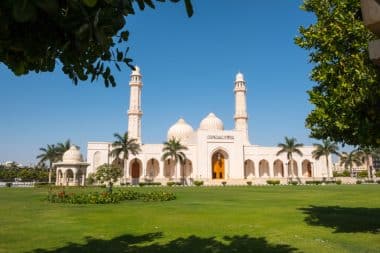
Welcome to Salalah, the city of the frankincense trade
If you want to immerse yourself in the local culture in addition to relaxation and sporting activity on the beach, you can dedicate yourself to the incense trade. Salalah stands in a centuries-old tradition in this regard and is still considered the global center of the frankincense trade today. At the Al-Husn Souk, you can look over the shoulders of the incense burners. The ancient frankincense port of Al-Baleed on the eastern edge of the city is a UNESCO World Heritage Site. It is not a functioning port, but an archaeological excavation site that can be visited. Right next door, the Museum of the Frankincense Land beckons, which not only provides information about the trading history of the valuable commodity, but also provides a small overview of the history of Oman. You should also not miss a visit to the Sultan Qaboos Mosque. Although it is not antique, it dates from the 21st century, but it looks powerful and is richly decorated and designed. Finally, you can take a look at the Sultan’s Palace, which can be visited from the outside.
And Salalah is also a true paradise for bird lovers. Guided birdwatching tours are offered everywhere, allowing visitors to get up close and personal with cormorants, colourful flamingos, collared parakeets and Bonelli eagles. However, the bird species mentioned are only a few examples of birds that can be admired around the city, which is located on the flight path of many European species in and out of their winter quarters.
Then it’s on to the cute sea creatures that cavort around Salalah. The starting point is the port of Salalah, from where dolphin safaris with excursion boats depart. The organizers know exactly where dolphins or humpback and blue whales like to stay and guide their guests directly there.
Wadi Darbat, the desert oasis
Sultan Qaboos Mosque in Salalah, Image: Patrik Dietrich / shutterstock
An excellent excursion destination into nature is Wadi Darbat. The village of the same name is located just under 60 kilometers from Salalah and is best reached by rental car. There are various hiking trails on site, which lead through a barren desert landscape or a lush green oasis. Depending on whether the excursion is made during the rainy or dry season. The landscape around Wadi Dabat is always beautiful. In addition, cave paintings can be visited and desert tours on dromedaries can be undertaken. The highlight of the desert oasis are several waterfalls that appear out of nowhere in the middle of the desert.
The coastal city of Mirbat
Another popular destination is the city of Mirbat, 75 kilometers from Salalah. Mirbat is a mixture of a traditional fishing village and a modern trading place. In the harbour you can see the typical dhow boats, old fishing boats. There you can still watch the fishermen doing handicrafts-oriented work. You can watch how they pull the fish out of the nets and sort them and then mend the nets and hang them up to dry.
With around 1.2 million inhabitants, Mombasa is a true metropolis and, after the capital Nairobi, the second largest city in Kenya. Many tourists from abroad visit Kenya to experience exciting safaris and get up close and personal with exotic wildlife. Safaris can of course also be undertaken from Mombasa. In addition, the city on the Indian Ocean is also ideal for a fantastic beach holiday. After all, the city is largely located on Mombasa Island. This is an island enclosed by the mainland on three sides with an area of 14 square kilometers. For example, Mombasa’s old town is located here, while some more modern districts are located on the mainland. All around there are numerous city beaches with pristine white sand.
Tips on how to get there and the best time to visit Mombasa
Fort Jesus – medieval fortress in Mombasa, Kenya, Image: kavram / shutterstock
Mombasa is not served directly from Germany , usually a stopover is necessary. Nevertheless, the connections are good and frequent. The airport is about half an hour by car from downtown Mombasa. In addition to a passport, tourists also need a visa to enter the country, which can be applied for online before departure. If you would like to spend a beach holiday in Mombasa, it is best to travel between mid-December and mid-March. Because then it is the dry season and it hardly rains.
Temperatures are relatively constant around 30 degrees throughout the year. From the end of March to mid-June it is correspondingly warm, but then it is rainy season in and around Mombasa. If you are interested in a safari, Mombasa is preferably visited between June and October. At this time, most of the different wild animals can be admired, because this is the phase of the regular animal migration in Kenya.
Mombasa’s most beautiful beaches
Fantastic beach in Mombasa, Image: Plun Lix / shutterstock
If you want to go to the beach in Mombasa, you are spoilt for choice. At the foothills of the inner city area, one beach section connects to the next. There are a lot of hotels here that operate their own beaches. However, most of the beaches are open to the public. Mombasa Beach, for example, is very pretty, whose white sandy beach is lined with tall palm trees. The infrastructure here is excellent and offers everything you need for a beach holiday: bars and beach cafés, restaurants, sun loungers and sports facilities.
Mombasa beach is just a few steps away from the old town. 35 kilometers south of the city is Diani Beach. It is considered one of the absolute dream beaches on the Indian Ocean. Diani Beach is no less than 25 kilometres long and therefore offers something for every type of beach. There are busy, but also very lonely beach sections. Diani Beach is even very interesting for divers, because there are some reefs off the beach where the colorful underwater world of Kenya can be discovered. In addition, the reefs ensure that the waves at Diani Beach hit very gently. They also keep sharks away and thus ensure safe bathing pleasure.
A walk through Mombasa
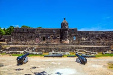
Mombasa’s old town looks winding and enchanted and the best way to go on foot is to go on a sightseeing tour through the narrow old town streets. The Portuguese heritage of the city becomes obvious right away. Numerous buildings have been built here in the Portuguese style. But Arab and Asian traders have also left their mark on the former port and trading metropolis. For example, there is a wholesale market where the spice and food traders line up colourful stalls. The crowd looks like an Arabic souk. You should also definitely visit the fortress Fort Jesus, which was built here in 1593 by the Portuguese. The building, which is a UNESCO World Heritage Site, stands directly on the Indian Ocean. The fortress is now partially destroyed, but still houses a museum that provides information about Mombasa’s history as a trading center. The Pembe Za Ndovu is considered a landmark of Mombasa. It is an outdoor sculpture that shows four elephant tusks tilting towards each other. The tusks are not real, but made of aluminum and form the gateway to the old town.
Experience the wild wildlife of Africa
For animal lovers, there are a variety of opportunities in and around Mombasa to experience a wide variety of animal species in the wild, or at least under natural living conditions. Just outside the city gates of Mombasa is Haller Park. Here, visitors can walk independently through forests and palm avenues on designated hiking trails. Hippos, zebras or giraffes and 160 different bird species can be encountered, including pelicans. Just a few kilometers away is the Mombasa Marine National Reserve, an underwater park. Here, you can primarily see fish and sea birds above the water surface.
The Mamba Village is a snake and crocodile farm where you can get close to these species under the supervision of animal keepers. If you want to go on a real safari with all the wildlife that the African continent is known for, you can go 180 kilometers from Mombasa in the Tsavo East National Park. Elephants, lions, buffaloes or giraffes, for example, cavort here. Halfway here, it is recommended to make a stopover in the Shimba Hills Reserve, which is 50 kilometers from Mombasa. The number of different animal species is not quite as wide as in Tsavo East National Park. On the other hand, the Shimba Hills Reserve captivates with scenic charms.
Almost circular, furrowed from the core of gorges, the third smallest island of the Canary Islands lies in the Atlantic Ocean and attracts with its untouched nature. Banana plantations, palm groves, a simple rural way of life and the 1970s of the hippies, who once discovered the archipelago for themselves, still characterize the Canary Island of La Gomera today.
The authenticity, naturalness and authenticity of the island is remarkable. Sometimes La Gomera can also be quite kitschy. At the latest when a dolphin jumps out of the Atlantic in a perfect arc or the glowing sun ball dives into the sea and glides smoothly back into the water. The island of Gomera, located off the northwest African coast, is of volcanic origin and exceptionally beautiful.
Simply wonderful, La Gomera. Image: ravelinerin / Pixabay
La Gomera is about 10 million years old. The island keeps many secrets, arouses curiosity and also raises some questions: Is there really an organ in the sea? How dangerous is a jump into the water? Who is lurking behind the stone nests? And what exactly is the Salto del Pastor? It is worth learning a lot more about La Gomera.
Fog-shrouded highlands, rainy north, barren and dry south – La Gomera combines very different climate zones in a very small area. Everything is close together here. While sun worshippers enjoy a wonderful beach feeling, weatherproof hikers walk only a few kilometers further through a mysterious cloud forest. One thing is certain: Most of the island’s highlights reveal themselves in their diverse and unique nature.
The north of La Gomera – not only a hit for hikers
The rich north can do more than just rain. It attracts visitors with pretty mansions, old churches and traditional handicrafts. First, hikers and adventure seekers penetrate the ancient laurel forest. Enchanted, it unfolds its entire beauty. Every now and then it can get really creepy: Suddenly gusts of wind howl, the damp humus soil unfolds a musty smell, and in addition, the creaking branches of the mighty treetops sink into the ghostly field of fog.
“Isla Magica” is the name given to the notorious mixed forest in the Garajonay National Park. Locals even suspect that this is a meeting place for the witches. Like an oasis, the forest stretches up to 1500 meters above sea level in a wild, torn mountain landscape.
The Gedro Valley is the centre of the national park. Here flows a bubbling stream, entwined with ivy. Over small wooden bridges, past waterfalls, you soon reach a clearing. Here lies a picturesque enchanted chapel.
But that’s not all. Agulo is the capital of the smallest municipality of the same name. Probably the most beautiful village on the island is presented on a 200-metre-high rock dome above the sea. From here, visitors can enjoy an overwhelming view of the neighbouring island of Tenerife. The centre of Agulo is also well worth seeing.
Los Órganos is no less exciting with a natural wonder located in the cliffs of the northwest. More on that later.
The south of Gomera – picturesque harbours and a sea of palm trees in eternal spring
Together with the ferry port, the city of San Sebastián forms the center of the southeast coast of La Gomera. In the immediate vicinity of the harbour there are many historical buildings from the time of the conquest. San Sebastián is the main town of the island and was also Columbus’ last stop before the sea voyage across the Atlantic.
In the church “La Asunción” there are many reminders of it. This is also the case in the “Torre del Conde”, the count’s tower from the 16th century. Also worth seeing is the old customs house, which was also used as a prison for a time, as well as “Casa Bencom”, the “Museum of Stones”. Here visitors learn all kinds of interesting facts about the origin of the island.
The small Bergorf Arure is located on the edge of a wonderful valley. Arure is the first town above the Valle Gran Rey. Traditional stone houses adorn the old settlement, which is located at an altitude of 825 meters in a picturesque landscape. People like to linger here. The restaurant “El Jape” spoils visitors with regional delicacies.
In the valley of the “Great King” – “Valley Gran Rey” – time seems to have stood still. At the edge of the world, you can enjoy and relax. Nothing is built up here, no hustle and bustle, here and there a few people sit around on the beach. The former hippie paradise is charming, impresses in a great location and shows itself in many places as alternative. White houses nestle against the terraced mountain slopes. The port district of Vueltas forms the tourist center of this region with La Puntilla, La Playa and La Calera.
La Gomera and the most beautiful beaches
Playa de Santiago is the island’s sun-drenched holiday centre with beautiful beaches.
The “Valle Gran Rey”, which is well developed for tourism, offers a special variety of beaches. Just behind the harbour pier is the sandy beach Playa de Vueltas. The beach is particularly popular with families and children due to its sheltered location from the treacherous surf.
Bathing like in a small pool – Babybeach, the mini beach near La Puntilla, offers even more protection. Rocks and stones form a kind of lagoon here and allow carefree bathing fun.
Starting at the headland of Puntilla, the longest beach of La Gomera finally stretches out. The shallow shores and the rather calm sea are bustling with tourists and locals.
And what about the organ? Of course, our questions do not remain unanswered:
In fact, it exists, the organ in the sea: Los Órganos is a church organ carved into the rock. This wonder of nature can only be reached by sea. Prismatic basalt columns line up on an 80-metre-high and 200-metre-wide rock face. The exposed basalt columns look like pipes of a huge organ. A jewel of nature, whose incredible beauty regularly takes visitors’ breath away.
Jumping into the sea is actually not entirely safe in some places. Especially where the strong current and sharp rocks make the jump a dangerous undertaking. There are hardly any bathing spots in the north of the island – the suction is too unpredictable, the waves too violent. On the other hand, you can enjoy exuberant bathing fun on the southern half of Gomera. Here you can play it safe: San Sebastián, Playa de Santiago and Valle Gran Rey.
What are the stone nests all about? It also remains a mystery for long-time Gomera travelers: The beach at Playa de Inglés seems to come and go as it pleases. Regardless of the tide and season – black gravel remains. When the rock exceeds the size of the gravel, the sun worshippers build large stone nests. In this way, they protect themselves from the wind and prying eyes.
The Salto del Pastor was once a special technique used by goatherds to make it easier to move on steep terrain. The shepherd’s leap was created. For this you need a wooden pole (astia) up to 3.50 meters long with a metal tip on top. This allowed the shepherds to overcome steep slopes, terraces, deep ditches and the ascent without any problems. Today, the Salto del Pastor on La Gomera is a popular leisure sport.
Sights and experiences on La Gomera”: From cloud forest to beach paradise
The island of La Gomera is characterized above all by its breathtaking nature and its numerous small beaches. If you are on holiday on the island, you should definitely bring sturdy shoes. After all, there is a lot to discover here on countless long and short hiking trails.
Island capital San Sebastian de La Gomera: Under the sign of Christopher Columbus
San Sebastian, the island’s capital of La Gomera, Image: Mikadun / shutterstock
If you are looking for sights, you will find them in the island’s capital San Sebastian de La Gomera in the east of the island. The small town of 9,000 inhabitants is mainly dedicated to the circumnavigator Christopher Columbus, who stopped here again and again on his voyages to America. In the Casa Colón Roundhouse, you can learn a lot about the explorer and his time on the island. La Casa de la Aguada also has a permanent exhibition on the discovery of America. You should also pay a visit to the Torre del Conde from the 15th century, which is still very well preserved. The impressive Church of the Resurrection Iglesia de la Asunción with its many small and large sacred works of art is always worth a visit. A leisurely stroll through the many narrow streets of the historic old town and a coffee in one of the numerous cosy cafés should also not be missed.
Los Organos Natural Monument and Garajonay Cloud Forest
If you are traveling in the north of La Gomera, you should definitely make a detour to the huge natural monument Los Organos on the north coast. The 175-metre-wide and 80-metre-high rock formation is probably the most famous sight and is also the island’s landmark. The Garajonay cloud forest in the interior of the island, which is about 2,000 years old, also attracts thousands of tourists and locals every year. As one of the oldest cloud laurel forests in the world, it is one of the most popular attractions on the entire island.
Due to the constant fog rain, a species-rich flora and fauna with 1000 different animal and almost 500 plant species has developed on the 4,000-hectare area. Among other things, green ferns up to two meters high can be found here. In addition, countless bird species, reptiles and amphibians live in the incredibly exciting national park. Instead, there are very few mammals here. In addition to animal and plant fans, hikers also get their money’s worth in the region. The national park, which is mainly characterized by the Canary Island jungle, has been a UNESCO natural heritage site since 1986 and is also a huge European bird sanctuary, is a real natural paradise for all visitors. The entire area is characterized by countless hiking trails with different levels of difficulty, making it a real paradise for hikers.
Original villages in the north, wide beaches in the south
View of the village of Agulo, Image: Mikadun / shutterstock
In general, the north side of the island is just as popular with hikers and climbers as it is with young and old nature lovers. If you are looking for tranquil holiday resorts away from the big tourist crowds, this is also the place for you. In Agulo, the smallest municipality on the island, as well as in the small village of Playa de Alojera, you can get to know the original La Gomera with its many narrow streets and small houses. A popular starting point for hikes is also the village of Vallehermoso. Nearby is the Castillo del Mar, an elaborately restored former loading station for bananas, a real eye-catcher that can also be found in many holiday photos.
Not far away is the settlement of Hermigua, which is best known as the largest banana-growing area on the island. And if you’re already out and about here, you shouldn’t miss the El Chorro waterfall. Those seeking relaxation and beach holidaymakers are in the right place in the south of La Gomera in Playa de Santiago. The region around the southernmost town of the island, which also has a small harbour, is characterised above all by its sunny location and its numerous beaches. The long and impressive waterfront is home to numerous bars, restaurants and clubs. In the summer months, it is really busy here, especially in the evening and night hours – as well as in the bungalow village Jardin Tecina, which is located in the east of Playa de Santiago.
Also very popular with tourists and locals is the Valle Gran Rey in the far west of La Gomera. Due to the extremely mild climate, in addition to the many beautiful sandy beaches, the most popular tourist center of the island with numerous water sports and a lively nightlife has developed here in recent decades – including in the small towns of La Puntilla and La Playa
The SSS Islands are a group of three islands in the Lesser Antilles in the Caribbean. They belong to the territory of the Netherlands and are among the “Leeward Islands” in the Caribbean.
The two islands of Sint Eustatius and Saba have the status of a “Special Municipality of the Country of the Netherlands”. In addition, there is the Dutch part of the island of St. Martin: Sint Maarten is an autonomous country within the Kingdom of the Netherlands.
On the island of Sint Eustatius live about 3142 inhabitants on an area of 21 km².
The island has been a Dutch colony since 1816. Since 10 October 2010, the island has been part of the Netherlands as a “Special Municipality”.
In the 18th century, the island was very prosperous through trade. However, the end of the slave trade, the supremacy of the now independent USA in transatlantic trade and the French occupation of Sint Eustatius in 1795 brought the economic heyday of the island to an end.
The official language is Dutch, but the English language dominates everyday life. As an overseas territory, the island is not only part of the European Union. Therefore, the currency is not the euro, but the US dollar. The capital of the island is Oranjestad.
The island owes its formation to volcanic activity. The almost 600m high volcano “The Quill” is now a dormant stratovolcano. Nevertheless, the volcano is still active today, as evidenced by temperature measurements in the groundwater of the volcano. Its crater attracts many tourists.
Sint Eustatius has tropical temperatures. Hurricanes are possible in the months of August to October.
The island has an airport and a port for ferries. Cruise ships cannot call at the port. Your guests will be taken to the island by tender boats. Worth seeing are the Quill/Boven National Park, the Fort de Windt and the St Eustatius Historical Foundation Museum.
Saba
A picturesque village on Saba, Image: Erika Bisbocci / shutterstock
The island of “Saba” is also a special municipality of the country of the Netherlands. The floor area of Saba is only 13 km². As of January 2021, 1918 inhabitants were registered on the island.
The capital of Saba is “The Bottom”. As in Sint Eustatius, Dutch is the official language in Saba. Everyday life is dominated by the English language. The currency is the US dollar.
Saba has no natural beaches. The island is surrounded by cliffs. Geologically, Saba is one of the young islands. It was formed by volcanic activity during the last 500,000 years. The volcano “Mount Scenery” occupies large parts of the island’s area. It is 877 meters high and is one of the dormant volcanoes. The last eruption is dated to 1640. Curiously, the volcano is the highest elevation in the entire Kingdom of the Netherlands.
Climatically, Saba is also one of the tropics. Cool trade winds from the northeast make the temperatures a little more bearable.
In colonial times, the rainforest was completely cut down. Today, however, there is again a very diverse secondary rainforest on the island, through which numerous hiking trails lead. Since there are no poisonous or dangerous animals on Saba, a hike through the rainforest is highly recommended.
However, you have to expect many mosquitoes, especially in the rainy season.
A hiking trail also leads through the rainforest to the summit of Mount Scenery.
Divers will find good conditions in the sea off Saba. The underwater world is protected by strict regulations and laws.
900 steep rock steps lead from the capital down the cliffs to Ladder Bay. Until the 2nd half of the 20th century, the island could only be entered via this arduous path. All goods and commodities also had to be transported on this route. Since 1960, Saba has had a small airport with an extremely short runway. A longer runway was not possible, as the airport was already being built on the only possible level of the island.
The most important economic sector today is tourism. Saba is very popular with divers. The island even has 4 decompression chambers for exchange accidents.
Sint Maarten
Cupecoy Beach on Sint Marteen, Image: Steve Heap / shutterstock
Sint Maarten is the southern part of the Caribbean island of St. Martin. The northern part belongs to France. It is an autonomous country that belongs to the Netherlands. Accordingly, the Dutch King Willem-Alexander is also the head of state of Sint Maarten. About 40,614 people live on an area of 34km².
A good 65% of the population are Dutch. They are descendants of Dutch settlers. Almost 75% of the population belong to the Christian faith. The capital of Sint Maarten is Philipsburg. The official languages are English and Dutch.
Sint Maarten is a tax haven. The companies that are registered on the island but do not do business in the Dutch part do not have to pay tax. VAT is only 5%.
Sint Maarten is often visited by cruise ships. The free port allows guests to shop tax- and duty-free. They therefore like to use their stay in Sint Maarten to buy tobacco products and spirits at low prices.
Sint Maarten is also famous for its airport. The runway is located directly on the beach and the planes fly directly over the heads of the bathers.
For example, it is possible to stand directly under an aircraft and photograph it from below. This is not entirely without danger, and so there are also warnings on the section of beach that is open to tourists.
Dreamlike beach idyll, breathtaking diving areas and lots of holiday flair: that’s Nauru. Despite its numerous advantages, the island state in the middle of the Pacific Ocean is still a real insider tip for tourists. Away from the big tourist crowds, you can enjoy a dream holiday with all the trimmings on Nauru, the only Pacific island in Oceania and the third smallest country in the world. There are only about 13,000 inhabitants living on Nauru.
The entire island, which is only 21.3 square kilometers in size, can be explored in just one day. Nauru does not have an official capital, but the political center is located in the district of Yaren in the southwest of the island state. In addition to the numerous political authorities, the metropolis of 5,000 inhabitants is also home to the International Airport of the Republic of Nauru. A leisurely stroll through Yaren is definitely worthwhile. In addition to the parliament building, which is well worth seeing, you should definitely take a look at the impressive harbor. Right next to Nauru International Airport is the Moqua Well. The approximately 2,000 square meter underground freshwater lake is located in a small cave a few meters underground. The lake offers both locals and tourists a welcome cooling, especially in the hot midday hours.
Coral rock on the beach of Anibare, Nauru, Image: Robert Szymanski / shutterstock
Divers and snorkelers from all over the world in particular have long since discovered Nauru for themselves in recent decades. No wonder: after all, the island is famous for its large and extremely colorful coral reefs and numerous small and large sea creatures. The reefs are among the most beautiful diving areas in the entire region – and that away from the big tourist strongholds of the Pacific. One of the most popular destinations on Nauru is Anibare Bay in the east of the island. The region is also the tourist center of the small state.
Water sports enthusiasts get their money’s worth here, as do beach holidaymakers and those seeking relaxation from all over the world. However, in addition to the dangerous jellyfish, you should also be careful of the unpredictable underwater current. For some years now, there has also been a seaport in Anibare Bay, which attracts many tourists in addition to the locals. In the west of the island state is another attraction, the Command Ridge. The highest point on the island with a height of 65 meters played a strategically important role for the Japanese army that occupied Nauru during the Second World War, especially during the Second World War. Even today, there are some remains of the various bunkers to be seen here. In addition, you can enjoy a nice overview of the entire island from here. Amateur golfers can also look forward to an 18-hole golf course.
Center of phosphate mining
In recent decades, Nauru has also been known as an important centre of phosphate mining. Due to the rich phosphate deposits on the island, Naura, which gained independence in 1968, was the country with the highest per capita income in the world until the end of the 1990s. From 2000 onwards, however, the deposits gradually ran out, so that significantly less phosphate is currently mined and thus poverty is becoming more and more rampant. In recent years, tourism has been discovered more and more as another important economic pillar for Nauru. Years of phosphate mining have created lunar landscapes all over the island. Today, these can be explored either on your own or with an expert guide. Due to the long-term phosphate mining on the entire island, there is a rather sparse flora and fauna on Nauru – especially inland. Only in the coastal regions can typical Pacific island plants such as coconut palms, banana trees or hibiscus be found. Large land animals are not found on Nauru. On the other hand, you will definitely find what you are looking for when looking for birds. Among other things, there are seabirds such as terns, gannets or shearwaters.
Best time to visit Nauru: from March to October
The weather on Nauru is characterized by a tropical climate with warm temperatures and high humidity of 75 percent on average. Rainfall is to be expected almost daily. The best time to travel to Nauru is from March to October. In these months, it actually rains relatively rarely. The average temperatures are just under 30 degrees Celsius. The dry trade winds make the weather even more pleasant. In the winter months, on the other hand, numerous heavy rainfalls are to be expected. Especially in the coastal regions, there are numerous accommodations to be found – from luxury hotels to various small holiday apartments to an inexpensive hostel.
The time of caravans is over – also in Mongolia and in the Gobi Desert. The camels, which for centuries were the most loyal companions of the nomadic people in this distant part of Asia, have had their day and made way for high-horsepower jeeps. Of course, there are still the Bactrian animals – around 600,000 specimens are said to live on the yurts of the desert dwellers, but they are almost only shown at the traditional Naadam festival or encouraged to race. Here and there there are even beauty contests for camels, and if you ask the Mongolians how to recognize a beautiful animal, they smile and say: “The camel must be big and stately – like humans…” But some things have been passed down from generation to generation in the Gobi Desert. Their songs and dances, which tell of their love for their homeland, of the loneliness of the steppe and of the eternally blue sky over Mother Earth.
A holiday camp in Mongolia, Image: toiletroom / shutterstock
When night falls over the desert and the full splendour of the Milky Way gradually unfolds in the sky, guests from another world also feel the melancholy of this remote region. The people of the Gobi are proud of their perseverance when they were threatened with religious persecution in times of oppression. In the meantime, most of them have returned to their spiritual roots and profess the Tibetan version of Lamaist Buddhism. The ceremonies of the shamans play a major role, especially in northern Mongolia.
The locals claim that the sandy hills of the Gobi Desert “sing” on some days. Geologists also know why this phenomenon occurs: the winds break on the rocks of the Gurwan Saichan National Park and the shifting dunes of Chongoryn Els produce these sounds. Since the times of the legendary Genghis Khan, the people of Mongolia have grown up with their “singing mountains”. Where there are still wild camels in the national park, Siberian ibex and here and there even a few specimens of the shy Gobi bears.
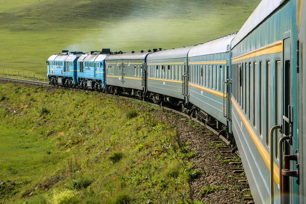
The Trans-Siberian Railway on its journey through Mongolia, Image: Yannik Photography / shutterstock
Mongolia has barely more than three million inhabitants – it is one of the most sparsely populated countries on the globe. And because holidaymakers don’t get lost here so often, the nomads of the desert meet them with a great open-mindedness and hospitality. Anyone who is greeted at a yurt is almost always offered a cup of Airag. This is the fermented milk of the mares. You have to like this drink – sometimes it is also combined with dried curd. From time to time, however, milk tea is also served.
Half of all inhabitants of Mongolia are settled in the capital Ulaanbaatar. One of the most famous sights of the metropolis is the Gandan Monastery, whose spiritual leader is the Dalai Lama. A 26-metre-high statue is dedicated to the goddess Janraisig. The imposing Blue Sky Tower, the tallest building in Mongolia, houses a luxurious hotel and a well-known revolutionary is honoured with a monument on the spacious Sukhbaatar Square.
But it is above all the vastness of the desert that characterizes this beautiful country. It is a country without a horizon and with a unique nature. According to the nomads, the sky is the seat of gods and demons. A camp at Gorkhi Terelj National Park provides intensive insights into the everyday life of the people of Mongolia, and those who are lucky enough to be part of a traditional Naadam festival will experience the country’s most skilled athletes archery, wrestling and horse racing. On a tour of this interesting country, the words “Sain Bainuu” will be the constant accompaniment. It simply means “Welcome”. Journeys through Mongolia guarantee variety and surprising impressions even in the monotony of the Gobi Desert.
Ulaanbaatar – steppe city between tradition and modern times
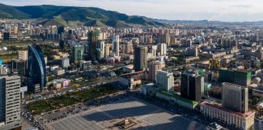
View of Ulaanbaatar, Image: Travel Stock / shutterstock
Wide, barren steppes, high rugged mountains, stone and sand deserts. This is the archaic landscape of Mongolia. The nomads who live there with their herds of sheep, goats and yaks are facing upheaval. Jeeps and trucks are now replacing their horses. Livestock breeding and agriculture are losing importance. The contrast between tradition and modern times is particularly evident in the capital Ulaanbaatar. In the city of 3.2 million inhabitants, modern skyscrapers stand next to Soviet palaces, prefabricated buildings next to huts and yurts.
While some have running water and electricity, others live in great poverty. Since the end of the Soviet Union in 1990 and the founding of the state of Mongolia, the city has changed. Tourists are impressed by the monumental Sukhbaatar Square in the center. In addition to magnificent bank and theatre buildings, the town hall and the stock exchange, there is the imposing parliament building, flanked by a large equestrian statue of Genghis Khan. Even more huge is another equestrian statue of Genghis Khan, which is a day trip away from Ulaanbaatar. It is 30 metres high and sits enthroned on a 10-metre-high base with kiosks. With a lift, tourists can ride up to the statue’s horseback. The important Gandan Monastery in Ulaanbaatar is worth seeing. It is the only one that was not closed in the Soviet era. Visitors should also not miss the Mongolian National Museum with its 15,000 exhibits and the palace complex of the Bogd Khan Palace Museum.
Genghis Khan orders the construction of the city of Karakorum
Long gone are the Soviet times, when many Mongolian art treasures were disregarded or destroyed. Karakorum is such a treasure. It is the sunken capital of the ancient Mongol Empire in the valley of the Borchon River, about 350 kilometers west of Ulaanbaatar. It was built in 1220 at the behest of Genghis Khan, but experienced only short periods of prosperity and was already destroyed in the 16th century. But their myth lives on and nourishes the national pride of the Mongols. Today it is a ruined city, an excavation site with a museum. In the Middle Ages, guest workers were brought into the country for the construction of Karakorum – mostly Chinese. They came voluntarily or were forced laborers.
Parisian guest worker forges silver fountain for ruler’s palace
Among them was the blacksmith Guillaume Boucher from Paris. Genghis Khan’s troops had abducted him from Hungary. But Boucher did not live like a slave in Karakorum. He earned a lot of fame because he had forged an elaborate silver fountain in the shape of a tree for the Khan Palace. Various drinks (fermented mare’s milk, wine, rice wine and honey mead) gushed out of four pipes of this beverage fountain, which were fed into four collection containers and refilled again and again. In the new millennium, German archaeologists also support the excavations in Karakoram, which are bringing more and more finds to light. For example, a bronze seal of the Minister of Finance from 1271 and a sophisticated water system built by the Chinese, as well as knives and coins, were found. In kilns, the archaeologists discovered bricks and clay figures.
Buddhist monastery “Erdene Dsuu” is located next to the ruined city
Very close to the ancient Karakoram is the Buddhist monastery “Erdene Dsuu” (“Precious Lord”), which has been revived since 1990 and is also a place of pilgrimage. Date of foundation: 1586. Unfortunately, the monastery was destroyed so often over the centuries that its monks were not allowed to experience a period of rest until the end of the 19th century. At that time, around 1000 monks lived there in 62 temples. For the rebuilding of the monastery, construction workers used stones from the neighboring ruined city of Karakorum each time. In 1937, during the Stalin era, the temple complex was again almost completely wiped out – only four temples remained standing. Fortunately, so is the imposing outer wall of the estate with more than 100 round towers. In addition to the richly decorated temples, three huge, carved stone turtles are a tourist magnet. They are said to come from Karakorum and were once the city’s landmark. In 2004, UNESCO declared the Orkhon Valley, where the monastery and Karakoram are located, a World Heritage Site.
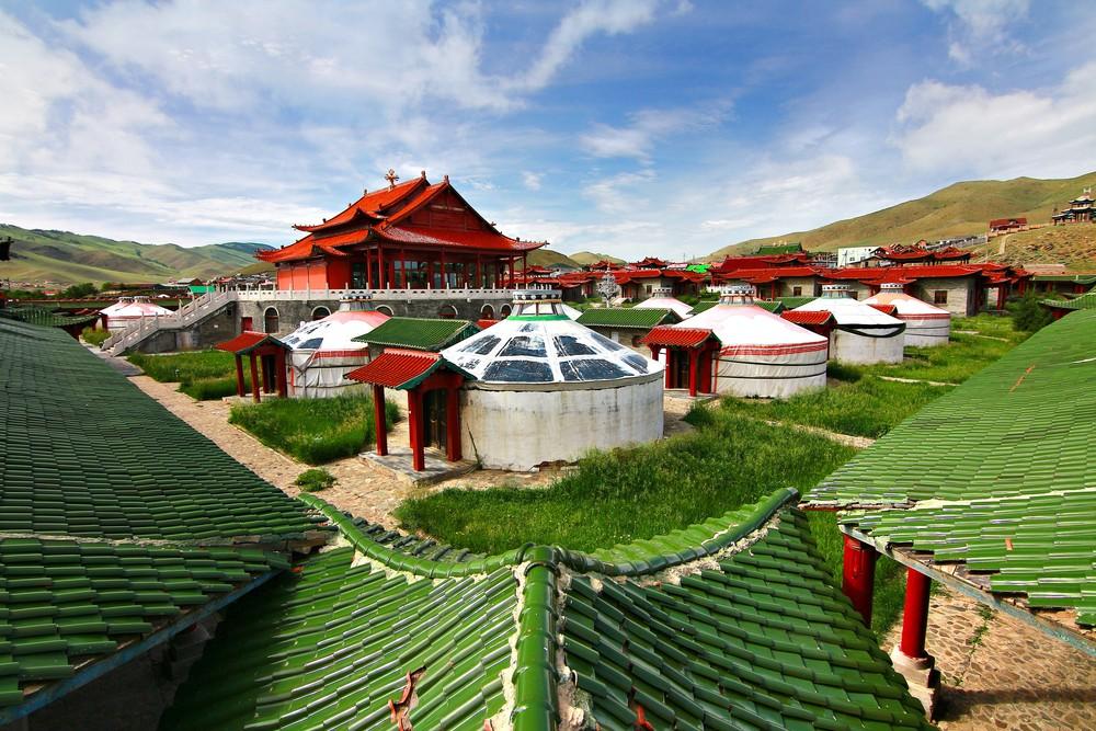
Gobi Desert: Spend the night in a yurt and ride camels
Gobi Desert , Image: Kokhanchikov / shutterstock
One of Mongolia’s most fascinating landscapes is the Gobi Desert, which covers 2.3 million square kilometers. However, Mongolia shares the unimaginable expanse with China. Sand dunes are rare in the Mongolian Gobi, scree deserts with bare rocks dominate. The wildlife is unique: Of the 5000 snow leopards that still exist worldwide, 700 live in the Mongolian Altai Mountains on the northern edge of the Gobi. The desert temperatures demand a lot from people, flora and fauna: While the maximum temperatures drop to -30 C and -40 C in winter, they rise to up to 35 degrees C in summer. The highlight of a trip to Mongolia is a guided tour through the desert lasting several days. Participants spend the night in yurts with nomadic families who are known for their hospitality. Visitors will then have the opportunity to ride horses and camels and sample local food such as salted butter tea, fermented mare’s milk, homemade cheese, and meat stews. For breakfast there is often fat mutton soup…
With the brown bears in Gorkhi-Terelj National Park
37 kilometers north of Ulaanbaatar is the Gorkhi-Terelj National Park. It is directly connected to the capital by a road. This protected area on the Tuul River is home to brown bears and more than 250 species of birds. While only the southern and smaller part of the park is equipped with restaurants, camps, souvenir shops, horse and camel riding stations, the much larger, northern part of the park is considered hardly accessible. During sightseeing tours, the rangers usually stop at Khagiin Khar Lake, the hot Yestii springs and the Buddhist monastery. Cameras and cell phones are pulled out when the famous rock formations in the shape of a turtle and an old, reading man appear.
As a fascinating and often underestimated destination, Angola has so far been spared mass tourism. This makes a trip to the south-west African country a special travel destination. In addition to lively cities and authentic villages, it is the beautiful nature of the country that captivates travelers.
Rich in mineral resources and uniquely beautiful in terms of landscape, Angola looks back on an extremely eventful history. For example, Angola’s colonial era was heralded at the end of the 15th century by Portuguese sailors who explored Angola from Congo. With the Portuguese, the slave trade also began in Angola, which was operated until the middle of the 19th century. According to estimates, over 2 million people were enslaved by the colonial rulers and sold mainly to South America. Officially, the country was declared a colony in 1653, although the military base of Luanda had already existed since 1575. The cane sugar and coffee plantations that are still in operation today also date back to colonization. In the 1960s, Angola was still ruled by Portugal . Again and again there were uprisings and it was not until 1974 that foreign rule ended. However, due to the unresolved balance of power in the country, there were repeated fights that led to a civil war in which countless people lost their lives. Traces of the country’s history can still be found everywhere today.
Today, Angola presents itself as an up-and-coming country and fascinates with its special features. The country is divided into three climate zones, which ensures a particularly diverse flora and fauna. But the cultural peculiarities are also fascinating and the unique sights of the country make Angola an interesting travel destination.
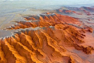
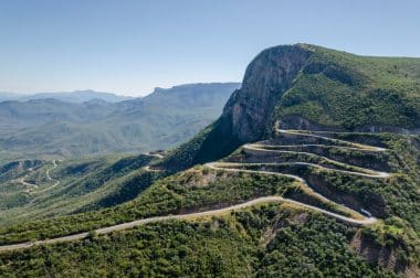
The impressive Serra da Leba pass in Angola, Image: Fabian Plock / shutterstock
With nine national parks, 18 forest reserves and protected areas, Angola is a true paradise for nature lovers. As early as the 1930s, protected hunting grounds were designated by the colonial administration. These areas are now part of the Kissama National Park. At 46,072 km², Murvinga National Park is the largest protected territory in the country. Africa’s fascinating wildlife combined with its uniquely beautiful landscapes captivate nature lovers from all over the world, making Angola a perfect place to go on a photo safari.
A special highlight is the Kavango-Zambezi Protected Area (KAZA). The area with its area of 520,000 km² is the second largest protected area in the world. The protected area includes a total of 21 national parks and game reserves, which are connected by corridors. In addition to the natural areas of Angola, natural areas in Botswana, Namibia, Zambia and Zimbabwe also fall within the special protection area. In addition to preserving biodiversity, KAZA is also intended to secure new development opportunities for the population, promote tourism and cross-border cooperation consolidate peace between nations.
M’banzai Congo – Angola’s first World Heritage Site
Once the political and spiritual capital of the Kingdom of Congo, M ́banzai Congo now invites you on a fascinating journey into the past. The UNESCO World Heritage Site includes archaeological relics of the former kingdom, which existed from the 14th to the 19th century. But the buildings of the Portuguese colonial era of the old town are also part of the World Heritage Site. Among other things, the ruins of a cathedral from the 16th century can be found in M ́barzai Congo, which is one of the oldest churches in Africa. But also remains of the royal plalast Tadi Dia Bukukua, the cemetery of the Congo kings and much more make a visit to M ́banzai Congo an unforgettable experience.
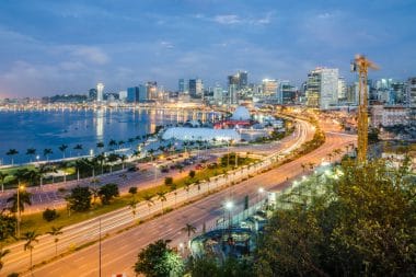
The capital Luanda
View of the skyline of Luanda, Image: Fabian Plock / shutterstock
Around 5 million people live in the capital of Angola. It is one of the largest cities in Africa and so there is always a lot of hustle and bustle on the streets. Particularly worth seeing is the Augostinho Neto Mausoleum, which characterizes the skylein of the city with its obelisk-like shape. The mausoleum is dedicated to Augustinho Neto, the country’s first president who fought for Angola’s independence.
One of the most important sights of the city is also the Fortaleza de Sao Miguel. The fortress was built in 1576 and was once the administrative center of the Portuguese colonial rulers. Today, the premises of the fortress are used as an army museum.
No less interesting is the Fortaleza de São Pedro da Barra, built in the 17th century. It was once built for protection, but in the course of history it was used as a transshipment point for the slave trade. Between 1961 and 1975, it served as a prison for Angolan nationalists during the struggle for independence.
Other cities in the country
Sao Felipe de Benguela
The city in Benguela Bay is the third largest in the country and the main base of the Benguela Railway, which runs through several African states. The city’s fortress is particularly worth a visit, as it offers a fascinating view of the Benguela.
Huambo
Located in the west of the country, Huambo was once called Nova Lisboa (New Lisbon). Today’s second largest city was founded by the Portuguese and even though the city has suffered from the war years, it is worth walking in the footsteps of history here.
Lobito
The port city, located on the Atlantic Ocean, is located on the Benguel Railway, which connects Angola with other African countries. However, the city is known for its port, which brought it a certain prosperity. The historic Governor’s Palace is particularly worth seeing.


 The new Aegean crime novel by Peter Pachel promises you even more exciting experiences on holiday on Amorgos.