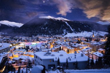
If you want to get to know Switzerland , you should not miss Davos. Because there are a few reasons to visit the popular climatic health resort. Davos is the highest city in Europe, located in the canton of Graubünden and offers its visitors a wide range of sports, leisure and cultural activities. In summer, Davos is a wonderful destination, because the mountain landscape offers many hiking trails through meadows and forests at lofty heights. Many holidaymakers are drawn here especially in winter, which is certainly also due to the city’s winter sports history. In 1883, the first toboggan race took place in Davos, and the first ski lift was inaugurated in 1934. Even the Nobel Prize winner for literature Thomas Mann was enthusiastic about Davos and wrote his well-known novel “The Magic Mountain” here.
The special healing climate in Davos
Davos is not only known for its beautiful surroundings, but also for its special healing climate. The healthy and healing power of the Davos climate is helpful in therapies against infectious and allergic diseases of the lungs and respiratory tract. The longer the duration of the stay, the greater the health-promoting effects. Pollen allergy sufferers also appreciate a holiday in Davos, because the pollen load is reduced to only a few weeks a year due to the altitude.
Davos – the versatile city
Davos developed into a trendsetter early on with a wide range of leisure activities. Theatres, coffee houses, concerts and cinemas entertained guests 100 years ago. Even today, Davos offers a wide variety of sports and culture with galleries and museums, as well as a wide range of nightlife options, including numerous ski huts, snow bars and après-ski.
Sights and tourism in Davos
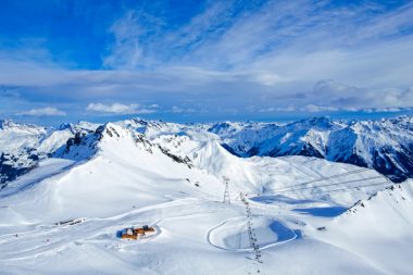
Winter sports are of course very important in Davos, which is also due to the total of five first-class ski resorts. The well-known ski resorts include Parsenn, Schatzalp, Jakobshorn, Rinerhorn and Pischa. In total, there are a good 320 kilometres of slopes here. In addition, there are about 60 lifts and gondola lifts. So a great skiing holiday is guaranteed.
In summer, you can explore impressive hiking trails with a total of 700 kilometers. Lake Davos is also worth a visit. With a shore length of a good 4 km, the lake can reach 20° Celsius in the summer months and offers many sports and leisure opportunities for water sports enthusiasts. In addition to Lake Davos, the lido also offers the opportunity for refreshment and extensive sunbathing. At the lake and also in the lido you can relax and unwind.
The Winter Sports Museum
The Winter Sports Museum, which opened in 1988, has two rooms. On display is the comprehensive collection of valuable winter sports equipment and documentation from a foundation of the Kaufmann family, as well as the archive of the hockey club. The museum’s numerous exhibits include bobsleighs, sledges, ice skates, skis and ski bindings. They range from the beginnings of winter sports to the present day.
The Medicine Museum at Davos Platz
If you are interested in the history of medicine, the Medical Museum Davos is the right place for you. Historical traces of medicine and the spa town of Davos are explained on display boards. Interesting details about the milestones in the history of tuberculosis and medical equipment of the first Davos sanatoriums can be admired in the museum. The medical-historical collection currently comprises more than 500 medical devices.
A visit to the Kirchner Museum
The unique Kirchner Museum is also worth mentioning. From 1918 until his death, Ernst Ludwig Kirchner lived in Davos. With his extensive oeuvre, he is considered groundbreaking for German Expressionism. In 1992, the Kirchner Museum was opened in an architecturally impressive building in Davos and has since housed the world’s largest collection of his works.
Alpinum Botanical Garden
The approximately two-hectare Alpine Garden is located in the rear part of the Schatzalp area in a varied terrain. From June to September, over 3500 plant species from all the mountains of the world bloom here, e.g. high mountain flowers from the Pyrenees, New Zealand, Nepal, China or Tibet. Each plant has its own sign listing the most important characteristics. Interested visitors can learn a lot about the botanical history of the various plants in the Alpinum. The Alpinum also offers seminars and guided tours on medicinal plants and gentle gardening.
Reading benches – A nice idea for bookworms
Along walking and hiking trails in Davos and Klosters, so-called reading benches are set up from June to October. On a total of eight benches, which invite you to linger and browse, there is a box with different books for all ages. The offer of the libraries is gladly accepted and finds more and more friends every year.