“Os Oche”, as the people of Aachen call their city in the deepest west of Germany, is a very special city. Aachen’s strength does not lie in the number of sights, but in the diversity and relevance of them. There is something for everyone here, so that even mixed tour groups are completely happy when they spend a few days in Aachen. You should definitely take a few days or a weekend to discover our favorite city.
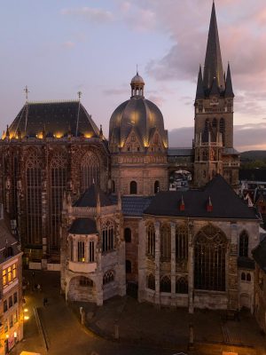
At the top of the list of sights – and by the way also on the list of UNESCO World Heritage Sites – is of course Aachen Cathedral. In the middle of the historic old town centre, it forms Aachen’s historic heart in an ensemble with the town hall. St. Mary’s Church was built by Emperor Charles, because his favorite place was also our Aachen. Attracted by the hot springs, he built his imperial palace here and ruled his empire from here – Aachen’s beginnings as an internationally important metropolis.
Over time, the former St. Mary’s Church has been expanded by various additions of the respective eras, so that today a visit to the cathedral alone is a whole journey through the history of Europe. If you walk through the entrance hall, you get directly into the octagonal heart of the cathedral and immediately lose yourself in the many details that affect you on the admittedly comparatively small building area. As far as this is concerned, the cathedral is just like the city itself.
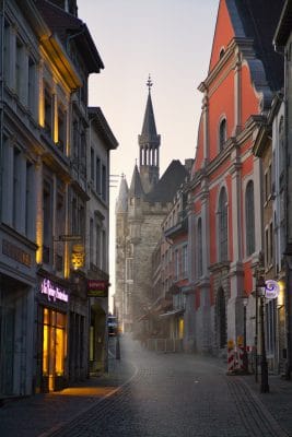
The people of Aachen were able to celebrate then as they do now. While the nightlife today takes place mainly on the upper Pontstraße, at the foot of one of the two remaining city gates, the Imperial Palace was the centre of the hustle and bustle at that time. The kings were crowned in St. Mary’s Church and there was a lot of celebration in the King’s Hall opposite.
Where the King’s Hall stood, the Aachen Town Hall stands today. Its mighty façade, decorated with numerous figures, rises above the market square and offers an impressive backdrop. The large coronation hall completely occupies the first floor of the mighty building and is still used today for important celebrations, such as the awarding of the Charlemagne Prize to high-ranking politicians from all over the world.
The cathedral and town hall can be visited on your own or as part of guided tours.
If you feel the urge for lunch after visiting the historical sights, you will certainly find something to satisfy this need along the old town streets and on the numerous squares. The only question is whether you can choose a restaurant from the large selection between Aachen breweries, restaurants of all conceivable nationalities or branches of international chains.
After refreshments, the other sights of the old town can be discovered. For example, there is the large Elisenbrunnen. It is one of the few places in the old town where you can still get close to the thermal water, which made Aachen famous and popular in its beginnings. However, fine noses should perhaps not get too close to it, because the smell of the water sometimes takes some getting used to. By the way, the west wing of the Elisenbrunnen is home to the Aachen Tourist Information, which was given a completely new look in 2021. Here, our experts advise our guests personally, sell tickets for the city tours that start here or provide explorers with city maps and insider tips.
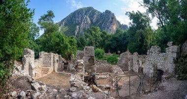
If you want to complete your excursion into the history of Aachen at your leisure, you are in good hands at the Centre Charlemagne, the new city museum at the Katschhof, exactly between the cathedral and the town hall. Here you can follow in the footsteps of five thousand years of Aachen’s city history and pass along the Carolingians, Charlemagne and modern Aachen.
As already mentioned – you can’t get by with one day in Aachen. If you have done enough research into the origins of Aachen or want to escape the hustle and bustle of the city centre, you will find a green refuge in Aachen in the immediate vicinity. To the north, for example, is the Lousberg, with a fantastic view of the city from one side, or the Horse Landscape Park in the Soers, behind the grandstands of the CHIO Aachen – World Equestrian Festival, on the other side. The hammocks on the Lousberg terrace are particularly suitable for this view. For the view of the city, you should choose the viewpoint at the obelisk.
Excursion to the border triangle
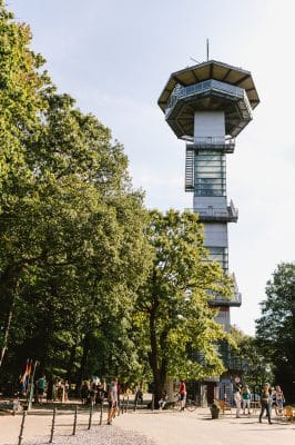
To the west is the three-country point as a popular destination for families and international tour groups. Hopping from one country to another and back, as the mood takes you, is how the idea of Europe can be experienced here. The experience is rounded off by restaurants, playgrounds, observation towers and a direct connection to the cross-border local recreation area Aachener Wald, which encloses the south of the city and is affectionately called “Öcher Bösch” by the people of Aachen. If you drive even further south, by car, express bus or bike on the Vennbahn route, you will reach the nearby Eifel with its national park and reservoirs.
In the city area, the Aachen Zoo is an attraction for families with children. The lovingly designed area with lake, discovery farm and petting enclosure delights guests of all ages and completes Aachen’s internationality in terms of wildlife.
However, if you are drawn back to the city centre, you will also discover many beautiful corners there. Perhaps while strolling through the numerous boutiques and shops of individual retail around the cathedral and town hall or in one of the numerous branches of international department stores. But perhaps also when admiring the Art Nouveau facades in the hip Frankenberg quarter or the villas in the southern quarter.
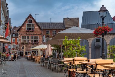
If your feet are flat, there is a smaller or larger square behind every corner with seating and nice encounters with real Öcher or people from all over the world who are in Aachen to study, work or even as tourists. Particularly popular are the courtyard in the old town with its Mediterranean flair, or the town hall steps on the Katschhof, which become the place to be in the old town on summer evenings and with self-catering brought along. If you end the day here, you are right in the right place to get started in Aachen’s nightlife with its bars, pubs and discotheques and fall into your hotel bed early in the morning.
If you want to or can deal with education the next day, you should take a look at the new, modern Aachen, which is about to go down in history to the same extent as in its early days under Emperor Karl. Throughout the city there are buildings of Aachen’s universities, all of which are known for their progress and spirit of discovery. This is where the technologies and ideas for tomorrow are developed, researched and implemented. Examples of this are the university district in the northwest of the city, the newly emerging Melaten campus and the futuristic university hospital, which polarises with its architectural appearance but is known for its high level of medical expertise. These locations and the people who make their heads smoke and their hands work there day after day complete the picture of Aachen as a versatile, lively innovation metropolis with great importance across all eras, which offers a high quality of stay for its guests.