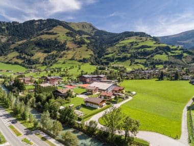
Mayrhofen is located in the upper Zillertal. The lively town attracts many visitors and holidaymakers again and again with a wonderful mountain world, wonderful hiking trails and interesting sights. In winter, the countless downhill runs make the hearts of winter sports enthusiasts beat faster. Nature lovers prefer to enjoy the summer in the mountains, with their countless hiking trails and the Zillertal mountain railways. Mayrhofen is the perfect holiday destination – because action, relaxation and fun are guaranteed here!
Excitement is in the air when the majestic birds fly over the heads of the spectators at the Ahorn Eagle Stage in Mayrhofen and demonstrate their spectacular flight manoeuvres. The one-hour bird of prey demonstration is a real highlight and takes place almost daily from mid-June to mid-October. From the mountain station of the Ahornbahn, the Adlerbühne can be reached in about 10 minutes.
Good prospects
To experience Mayrhofen yourself from a bird’s eye view and enjoy the magnificent mountain panorama – that is not so difficult. A paragliding flight from Action Mountain Penken to Mayrhofen offers this unique experience, because Mayrhofen is known for its special thermals and therefore offers wonderful high-altitude flights.
The view of the mountains
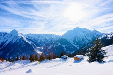
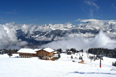
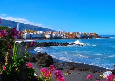
Mayrhofen scores with a great ski area, Image: Roman Babakin / shutterstock
If you want it a little more down-to-earth, you can take the Ahornbahn cable car to the leisure mountain Ahorn in a good 7 minutes. The Ahornbahn is the largest aerial tramway in Austria. The view through the huge panoramic glass fronts of the mountains is really impressive.
Fun and action
The action mountain Penken is the ideal destination for adventurers. Whether in summer or winter – there is always something going on here. The fun station is located directly at the reservoir of the Action Mountain. Who dares to roll over the reservoir with the large and air-filled Funballz? Or should it be a little more leisurely? With a mountain scooter, the mountain world can be explored comfortably on two different routes.
Pure Harakiri
In winter, brave winter sports enthusiasts can expect the steepest piste experience on the Penken. With a gradient of 78 percent, the “Harakiri” is the blackest slope in the entire Zillertal. It should therefore really only be skied by real experts. Exciting, but less dangerous, is the snowpark. The park, which makes every snowboarder’s heart beat faster, is located in the Horberg Valley on Action Mountain Penken. On the other hand, the Pistenbock on the Ahorn leisure mountain in Mayrhofen takes you downhill, a real tobogganing fun for young and old. The Pistenböcke can be rented at the bar of the White Lounge igloo village.
All cheese?
How does fresh milk from happy cows actually become cheese? If you want to learn more about this, you should visit the Zillertal Adventure Dairy. Through glass panes, the path from hay milk to cheese, butter or yoghurt can be precisely observed. If you get hungry for the delicacies afterwards, you can of course also taste them on the terrace, in the milk bar or in the restaurant. Of course, you can also take your favorite cheese home with you.
Amazement at the dam wall
Via the Schlegeis Alpine Road, you can reach the idyllic Schlegeis reservoir at 1,800 metres above sea level. Here you can take a hike around the lake or take an interesting tour of the Schlegeis dam. Inside the dam wall, the numerous measuring and control equipment, as well as the history of the 725-metre-long wall, are explained very well by expert staff.
The bells of Mayrhofen
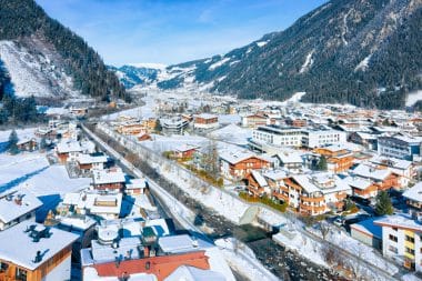
The Ziller flows through Mayrhofen, Image: Roman Babakin / shutterstock
In the centre of Mayrhofen is the white octagonal building with a Gothic choir and a church tower with a pointed spire. The 4 bells (twelve-bell bell, festive bell, prayer and work bell, soul bell) of the parish church weigh a total of 3,800 kilos. The church was built at the end of the 16th century. Also worth seeing is the impressive ceiling painting “Rose of Jericho” by Max Weiler.
Puffing through the Zillertal
Tourists and friends of historic steam locomotives can explore the beautiful Zillertal wonderfully and without stress with the steam train of the Zillertalbahn. With a maximum speed of 35 km/h, the nostalgic train covers a distance of 32 kilometres between Jenbach and Mayrhofen.
Facts about the ski resort in Mayrhofen
1. Location and accessibility
Geographical location: Mayrhofen is located in the upper Zillertal in Tyrol, Austria.
Accessibility: The ski area is easily accessible by car, bus or train. The nearest train station is in Mayrhofen, and from there there is a direct cable car connection to the ski area.
2. Slope length and variety
Total length of slopes: The Mayrhofen ski area offers a total of around 142 kilometres of slopes.
Schwierigkeitsgrade:
Blue slopes (easy): approx. 40 km
Red slopes (medium): approx. 66 km
Black slopes (difficult): Approx. 36 km, including the legendary “Harakiri” run.
Altitude: The slopes are located at an altitude of between 630 and 2,500 meters above sea level, which ensures snow-sure conditions.
3. Lifts and facilities
Number of lifts: There are a total of 45 lifts, including modern gondola lifts, chairlifts and T-bar lifts.
Modern infrastructure: The lifts offer a high transport capacity and are well distributed to minimise waiting times. The Penkenbahn and Ahornbahn are particularly fast and comfortable.
4. Ski season
Duration: The peak season usually starts in early December and lasts until mid-April, depending on snow conditions.
Snow reliability: Thanks to the altitude and state-of-the-art snow-making facilities, snow is guaranteed in winter.
5. Special highlights
“Harakiri” slope: With a gradient of up to 78%, the Harakiri slope is one of the steepest groomed slopes in Austria and a highlight for experienced skiers.
Penken Panorama Park: Here, winter sports enthusiasts can expect a magnificent panorama with various mountain peaks in the background.
Family Park Ahorn: Ideal for beginners and families, this area offers flat slopes and a child-friendly area for learning.
6. Freeride and off-piste opportunities
Freeride options: Action Mountain Penken offers numerous freeride routes and deep snow runs for experienced skiers and snowboarders.
Safety: There are avalanche warning systems and information on safety for freeriders throughout the area.
7. Snow parks and freestyle
Vans Penken Park: One of the best snow parks in the Alps with various lines for beginners to professionals, including a halfpipe, kickers, rails and boxes. The park attracts international freestylers and is a highlight for snowboarders and freeskiers.
8. Infrastructure and gastronomy
Huts and mountain restaurants: Numerous huts and mountain restaurants offer regional specialities and international cuisine. The “Panorama Restaurant Ahorn” and the “Pilzbar” on Penken are particularly popular.
Parking: There are plenty of parking spaces in the valley and shuttle buses that make the valley stations easily accessible.
Equipment rental: In Mayrhofen there are numerous rental stations for ski equipment, snowboards and protective equipment.
9. Family-friendliness
Ski schools: Several ski schools offer courses for children and adults, from beginner lessons to advanced training.
Children’s area and practice areas: Special practice areas and the “Ahorn Children’s Area” are ideal for families and beginners.
10. Après-ski and leisure activities
Après-ski: Mayrhofen is known for its lively après-ski offer with numerous bars, such as the Ice Bar and the Bruck’n Stadl.
Other leisure activities: Mayrhofen also offers winter hiking trails, a natural toboggan run and ice skating opportunities.
11. Special tips for skiers
Tip for advanced skiers: The “Harakiri” slope is a challenge suitable only for experienced skiers, but the descent is a must for those looking for thrills.
Families and beginners: Ahorn Mountain is ideal for beginners and families as it offers gentler and wider slopes.
Panoramic view: The Ahornbahn offers an impressive panorama of the Alps and is a great experience for everyone.
12. Accommodation
Hotels and guesthouses: Mayrhofen has a variety of accommodations, from simple guesthouses to luxurious hotels.
Ski-in/ski-out: Some accommodations offer direct access to the slopes or are close to the valley stations.
13. Weather conditions
Sunny days and guaranteed snow: Due to the altitude and good snow-making facilities, the conditions in Mayrhofen are very snow-sure throughout the season. Sunny days also offer spectacular views of the Zillertal Alps.
Skiing, snowboarding or even sledding – the winter time not only brings cozy TV evenings and icy cold, but also many opportunities to do sports. Snow and ice suddenly give rise to a variety of sports. Austria in particular is the pioneer par excellence when it comes to winter sports. Countless ski resorts and tourist attractions ensure that millions of people drive to the country every year and plunge down the slopes. It is not always easy to decide on the right region. Six of the most popular winter sports resorts are described in more detail below. So: book a winter holiday in Austria , hit the slopes, get set, go!
Centre of Ischgl, Image: Dreamer4787 / shutterstock
When you think of Ischgl, images of countless après-ski parties probably come to mind. The Silvretta Arena is Tyrol’s third largest ski area and offers slopes for professionals, beginners and families. Almost 45 lifts ensure that everyone gets on the slopes as quickly as possible. The ski area is internationally known and many celebrities cavort here. It can happen that suddenly a well-known star stands in front of you. It is also home to the largest snow and fun park in Austria’s ski resorts. Here, professionals and amateurs can show what they can do. Ischgl offers the perfect mix of winter sports and event location and is therefore rightly one of the most popular winter sports resorts in Austria
Sölden
Sölden in winter, Image: Goran Vrhovac / shutterstock
Sölden is a popular winter sports resort. This is mainly due to the fact that there are two glaciers here, the Rettenbachferner and Tiefenbachferner. This ensures that Sölden is a very snow-sure region. The slope length in the ski area is almost 144 kilometres and extends to an altitude of over 3,000 metres. Of course, this provides the extra portion of snow and an incredible feeling. Winter sports enthusiasts get their money’s worth here. By the way, parts of the James Bond flick “Spectre” were also filmed here in the region. That’s why there is a unique 007 adventure world here! But après-ski is also very important in Sölden. Many parties take place here every year in season and easily attract the crowds to the wonderful ski area.
Obertauern
Not only the province of Tyrol offers spectacular opportunities to really work out in winter, but also the Salzburger Land. This region is mainly designed for families with children and beginners. Countless easy and easy slopes ensure that even the little ones can ski here carefree. Don’t feel like skiing or snowboarding? Don’t worry! There is even a 6.5-kilometre-long toboggan run, which provides an extra portion of fun. Obertauern also offers many opportunities for snowshoeing. If you prefer a little more action, you can let loose at the fun parks on the slopes!
Flachau
Flachau in the Amadé ski area, Image: kamilpetran / shutterstock
Flachau offers snow fun on a completely different level. Not only is the Women’s Alpine Skiing World Cup held here, but everyone can feel like a professional here. Countless different slopes, such as the panorama route or the timed run provide variety and ensure that there is something for everyone. But the region is not only a true paradise for skiing and snowboarding, but also for hiking. There are over 40 cleared hiking trails around Flachau and can be used in winter.
Stubai Glacier/ Staubai Valley
The ski area around the Stubai Glacier offers plenty of variety. This is also one of the most snow-sure regions in Austria and thus ensures slopes until June. The area offers a lot of other attractions, besides beautiful slopes. A little next to the post is an ice grotto. It is a 200-meter-long ice cave that amazes everyone. At the Gamsgarten there is an area that is primarily designed for families. In addition to a family course and a wave run, there is also a children’s playground and a snow carousel.
Brixental Valley
Brixental is a village in Tyrol that lies near the Wilder Kaiser. The Wilder Kaiser is heavily visited at any time of the year. But especially in winter, many winter sports fans cavort here. This is where Austria’s second largest ski area is located, with a slope length of almost 300 kilometres. The huge area connects nine villages, all of which form their own ski areas. Skiing down the slope in one day is therefore almost impossible. However, it is even possible to drive here at night, or until 9.30 p.m. Countless hiking trails and cross-country skiing trails provide the necessary variety and let the beautiful nature shine in a different light.
The most popular winter sports resorts in Austria – Conclusion
Austria is a true paradise for winter sports fans and nature lovers. Countless ski areas provide plenty of fun on the slopes. But there is also a lot to experience and discover away from the slopes. Winter hikes, tobogganing or snowshoeing are only a fraction of the activities. The mountainous regions offer plenty of variety and opportunities for families and professional athletes. There are over 400 ski resorts in Austria and accordingly countless winter sports resorts. Finding the right holiday destination is not always easy. With this list of the six most popular winter sports resorts in Austria, there is a small insight into what to expect
Verbier, a quaint mountain village located above the Val de Bagnes in the Swiss canton of Valais, attracts hikers and ski enthusiasts from all over the world. As part of the “Les Quatres Vallées”, the largest winter sports area in Switzerland, Verbier is referred to by connoisseurs as the world capital of mountain sports. Here you can find out why a visit to the cozy mountain village is worthwhile all year round.
The region “Les Quatres Vallées” (4-Vallées for short) includes six villages, including Nendaz, La Tzoumaz, Veysonnaz, Thyon, Les Collons, Les Masses, Bruson and Verbier. All six villages are located south of the Rhône and extend over four side valleys, which is why the region is called 4-Vallées (French for four valleys).
The 4-Vallées ski area, which is now connected, did not come into being overnight, but has developed over many decades from skiing in the individual areas. The region is now criss-crossed by a seamless network of slopes and lifts. The three pioneers of Swiss winter sports and mountain railway operators, Rodolphe Tissières, Michel Michelet and René Fournier, had been pursuing this vision since the 1970s and achieved a breakthrough in the unification of the valleys in 1976 through the association of existing mountain railways and the construction of additional cable cars. Meanwhile, the ski area around 4-Vallées is so large that one visit is not enough to explore the entire variety of slopes, which distinguishes the 4-Vallées from the other smaller ski resorts in Switzerland. Despite its dimensions, the entire area of the 4-Vallées with its total of 410 kilometres of slopes can be used with just one ski pass.
Verbier’s unique winter fun – with and without runners
With the first snowfall, Verbier is transformed into a paradise for winter sports. A cable car leads to the highest point of the ski area, the summit of Mont Fort, which is located at around 3,300 meters above sea level and offers a breathtaking view of the Matterhorn, Mont Blanc and the Grand Combin. From there, you have a free choice of how to get on on ski slopes, snowshoe trails, winter hiking trails and cross-country ski trails.
As one of the largest ski resorts in Switzerland, Verbier offers pure skiing fun on over 200 kilometres of slopes in the months from November to the end of April. Both absolute beginners and daring advanced skiers get their money’s worth here on blue slopes, mogul slopes and world-famous freeride routes. The mountain village is also a stage on the so-called “Haute Route”, a ski crossing along breathtaking high alpine glacier landscapes in the direction of Saas Fee and Zermatt – a must for lovers of long ski tours.
Numerous marked winter hiking trails make it possible to discover the landscape on foot. Accompanied by the winter sun, kilometre-long hikes lead through snow-covered forests and over gigantic sun terraces with breathtaking views to rustic mountain huts where you can relax with coffee, hot chocolate or tea. Particularly popular routes lead from Périn to Les Planards or from Les Ruinettes along a wide path through the Alps towards Alpage de la Chaux.
Verbier is also at the top of the world in terms of tobogganing. The toboggan run from Savoleyres to La Tzoumaz is the longest toboggan run in French-speaking Switzerland and offers fast-paced fun for young and old over 10 kilometres long and over 800 metres in altitude.
If you still haven’t had enough in the evening after the action on the slopes, hiking trails and the like, you can enjoy the varied après-ski offer and the aperitifs of Verbier.
Even in summer there is a lot going on here
The Mont Fort, Image: mountainpix / shutterstock
Verbier is not only a winter sports mecca, but also offers pure fun in summer with its charming landscape on over 900 kilometres of hiking trails, 800 kilometres of mountain bike trails and perfect conditions for paragliders and climbers.
Verbier’s hiking trails stretch in the Val de Bagnes along the breathtaking backdrop of the Mont Blanc massif, Mont Velans and the Combins massif. Professional hikers can also explore the snow-covered mountain landscapes around Verbier in summer. And for those looking for something a little less action-packed, two golf courses and a sports club with sauna, tennis and squash facilities offer a weatherproof alternative.
If that’s still not enough, you get a huge range of international top events on top. In July, classical music lovers from all over the world come together at the 17-day Verbier Festival to forge a bond between old masters of classical music and talents from the younger generations against the backdrop of the magnificent Swiss Alps. Less cultural and more action is available on the Xtreme Verbier, the Freeride World Tour, where the world’s top freeride riders meet between March and April to reach for the world championship title.
… and it still remains cozy!
Despite the growth in tourism in recent years and the now about 4000 inhabitants, Verbier retains its village charm. Unlike surrounding ski resorts with a similar footfall, Verbier refrains from building huge hotels and instead remains true to the style of traditional slate-roofed chalets and small guesthouses.
Kos is a Mediterranean island in the eastern Aegean Sea. Visitors to the island, which is only 290 square meters in size, can expect many sunny days, beautiful sandy beaches and numerous sights. Kos lives mainly from tourism, so there is a lot of emphasis on the environment on the island. The wastewater is cleaned by biological sewage treatment plants and the beaches are cleaned regularly.
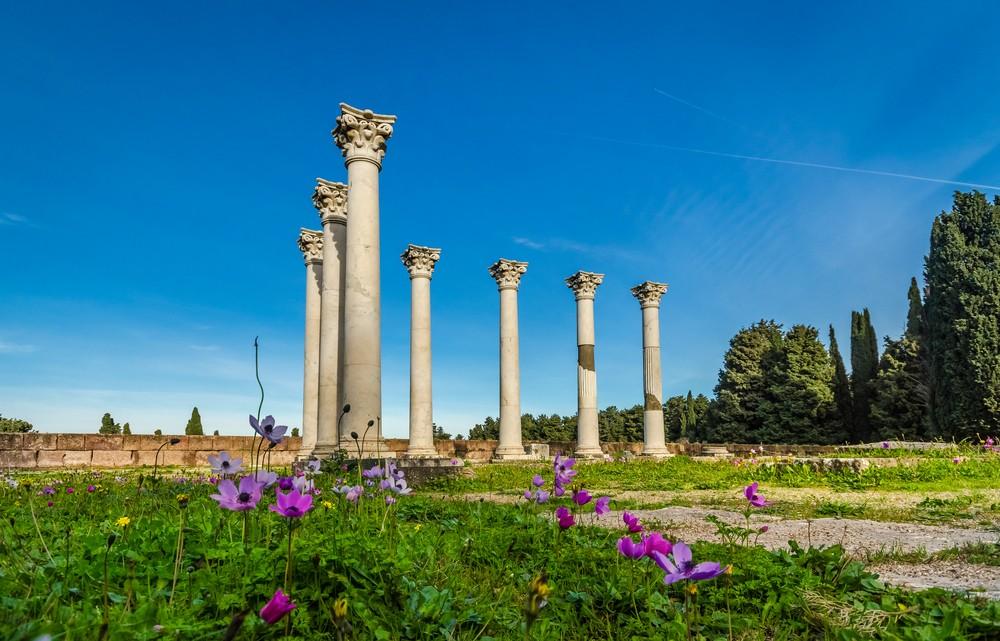
Asklepieion of Kos, Image: George Papapostolou / shutterstock
In the south of Kos, the 846-meter-high mountain Dikeos invites you to hike. It is the highest mountain on the island and rewards hikers after the ascent with a really great view of Kos and the neighboring islands.
Cyclists also feel at home on the island, as there are many well-developed cycle paths that lead along the coast or past almond trees, olives, lemon slopes and grape groves. Wild figs along the way are good for a small snack during the bike tour. Bicycles can be rented on the island for little money.
On the eastern south coast is the Embros Therme. From a crevice, almost 50 degrees hot sulphur water, which is said to have a healing effect, flows into a pool of about 30 square meters. A bath in the 30 – 40 degree warm rock pool is very relaxing.
Kos has numerous culturally interesting sights to offer. Not far from the capital is the main attraction of the island, the Asklapieon (ancient Greek sanatorium). It was named after Asclepius, the ancient Greek god of healing. The impressive complex is made up of several terraced levels, which are connected to each other by mighty marble staircases.
The Basilica of Kapama
Kavo Paradiso Beach, Image: George Papapostolou / shutterstock
The small town of Zipari is located about 11 kilometers from the town of Kos. Here is the Basilica of Kapama, which was excavated in the summer of 1936. It is interesting because of its baptistery. Interesting mosaics can be seen on the floor of the basilica.
The Market Hall in Kos Town
To the south of Platia Eleftherias is a market hall built by the Italians in 1934. Inside there are countless small stalls with fresh fruit and vegetables, but there are also many culinary offerings that do not come directly from the island of Kos.
Paleo Pyli
In the north of Kos is the ruins of an old castle complex embedded in an abandoned village. Paleo Pyli is one of the famous sights on the Greek island. It is believed that the romantic castle dates back to the 11th century. Today, the place looks partly like a ghost town, because many houses have unfortunately fallen into disrepair. But some buildings can still be visited. For example, the churches of Panagía ton Kastrianón and Asómati Taxiárches Gavriíl ke Miachaíl, built in the 11th century.
Peacock Forest Plaka Kos
Even from afar you can hear the calls of the peacocks from the peacock forest Plaka Kos. About 50 wild peacocks, turtles and free-roaming cats live in this pine forest. The peacocks are tame and like to be fed by visitors. There are tables and benches in the area that invite you to have a picnic in the middle of nature. A visit to the Peacock Forest is a great experience for the whole family.
The Alikes Salt Lake
On the northern coast is the famous salt lake Alikes. The former large salt works were closed in the middle of the 20th century. Since then, nature has reclaimed the area and has now been declared a nature reserve. A wide variety of wild or waterfowl have settled in this area to breed or spend the winter. Pink flamingos can also be observed at the salt lake.
The plane tree of Hippocrates
In Kos Town stands the plane tree of Hippocrates, it is said to be several hundred years old. According to reports, Hippocrates taught his students under this plane tree.
Beaches in Kos
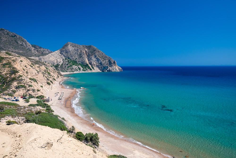
There are sandy and pebble beaches on Kos. The beaches of Kephalos in the southwest of the island or the beach of Tigaki, which can be found in the north of Kos, are recommended. There are fine sandy beaches and crystal clear waters. The way to Cavo Paradiso is a bit more difficult, but the beach is not overcrowded. The quiet sandy beach of Lagada Beach is well suited for a family holiday, as the beach here slopes gently into the sea.
Kefalos Bay, Image: Maciej Czekajewski / shutterstock
Divers and snorkelers can observe colourful lionfish in the crevices in Kardamena at a depth of four metres. Caves, rocky reefs and gorges are home to wrasses and octopuses. At the “Blue Hole” there are four shipwrecks on the seabed, which should be interesting for divers.
Greek cuisine
Well-known Greek specialties such as souvláki, moussaká or gyros are also available at the Greek home. Therefore, you should definitely try the diverse Greek dishes. On Kos, people like to eat offal and hearty pork dishes.
Typical dishes in Kos:
Sikóti – liver, often from veal, but also from chicken, lamb or pork
Margirítsa – the Greeks like to eat this slightly sour soup during the Easter Vigil. It consists of the innards of the lamb that is eaten at Easter
Revithokéftedes – potato pancakes or balls made from chickpeas
Ksismata – wheat bread kneaded with grated Myzithra cheese and herbs
Kokorétsi – offal wrapped in natural casing and grilled on a skewer
Oúzo – Anise schnapps and the alcoholic national drink of the Greeks. You drink pure, diluted with a little water or with ice.
Weather in Kos
Like many other Greek islands, Kos can reach peak temperatures of over 40° C. Rain is hardly to be expected between May and the end of October. The holiday season starts in May and ends in October. Most holidaymakers are on Kos from mid-June to mid-September.
Facts about Kos
Location: Kos is an island in the southern Aegean Sea and belongs to the Dodecanese archipelago.
Size: The island has an area of about 290 square kilometers, making it the third largest island in the Dodecanese.
Population: The population of Kos is around 33,000 inhabitants, with most living in the main town of Kos Town.
History: Kos has a long history dating back to ancient times. The island was known for its medical school, which was founded by Hippocrates, the father of modern medicine.
Sights: Some of the most famous sights in Kos include the Asklepieion, an ancient medical site, the Neratzia Fortress, the Roman Odeon, the Plane Tree of Hippocrates (a tree said to have been planted by Hippocrates), and the Knights of St. John’s Fortress.
Beaches: Kos has many beautiful beaches, including Tigaki Beach, Mastichari Beach, and Kefalos Beach.
Climate: Kos has a Mediterranean climate with mild winters and hot summers. The best time to visit is from May to October.
Tourism: Kos is a popular tourist destination and attracts many tourists every year, especially from Germany and the UK.
Transport: The island is easily accessible by ferries and flights from Athens and other Greek islands. On the island itself, there are also buses, taxis and rental cars for getting around.
Culinary: The cuisine of Kos offers many delicious specialties such as taramasalata, souvlaki, moussaka, baklava and the local wine “Aspro”.
The most beautiful beaches in Kos
Tigaki Beach – Located on the north coast of Kos, this beach is one of the most famous beaches on the island. The beach is about 10 km long and offers fine, golden sand and crystal clear waters. There are many facilities such as restaurants, bars, sunbeds and umbrellas.
Paradise Beach – Paradise Beach is another beautiful beach in Kos that is located in the southwest of the island. It is a secluded beach that can only be reached by boat or via a steep path. The beach offers fine white sand and crystal clear waters.
Kefalos Beach – Kefalos Beach is one of the longest beaches on Kos and is located in the southwest of the island. The beach is surrounded by picturesque mountains and cliffs and offers fine golden sand and crystal clear waters. There are many facilities such as restaurants, bars and water sports facilities.
Mastichari Beach – Mastichari Beach is a beautiful sandy beach on the north coast of Kos. The beach is not as crowded as other beaches on the island and offers crystal clear waters and picturesque views of the surrounding islands.
Psalidi Beach – Located near Kos Town, Psalidi Beach is a popular beach among locals and tourists. The beach offers fine sand and crystal clear waters, as well as facilities such as restaurants and bars.
The Hohe Tauern National Park is an interesting destination in all seasons to experience a relaxing holiday in an extremely charming landscape. Where mountaineers, cyclists and mountain bikers gather in summer and where people look for gold in the streams, winter holds the whole kaleidoscope of sporting activity. Rauris is one of the top addresses not only for sympathizers of the alpine variants of winter sports. This is a white gem in winter. Snowboarders are at home in the extensive Hochalmbahnen ski area. On the shallow slopes of this Austrian region, families with their children can also look forward to unlimited fun on the slopes.
It is said that the cold days of the year feel particularly pleasant in the Rauris Valley and that winter there almost always comes along with a cheerful charm. In the guesthouses and hotels of the village, hospitality is anything but a foreign word. Here the holidaymaker is “king” and is pampered in all respects in his accommodations. In the thirty-kilometre-long valley in the Salzburger Land between Taxenbach and Kolm Saigurn, dealing with the values of nature has always been a matter of course. This is the largest protected area in the Eastern Alps, and the people of this region see this as an obligation. The ski area is still clear and the construction of lifts was kept within rather modest limits. All investments were made with the environment in mind.
The Rauris ski region: tested and approved
After all, there are ten modern lifts available to winter sports enthusiasts in Rauris. They transport skiers to altitudes of up to 2,175 metres and to the starting points of the approximately 32 kilometres of slopes. The comfortable summit lift opens up a magnificent panoramic view of the mighty peaks in one of the most beautiful alpine areas in Austria. And since the safety of the guests is close to the hearts of those responsible, it plays a paramount role in Rauris. This is reflected in the verdict of skiresort.de. The world’s largest Internet portal, which has set itself the task of critically examining international ski resorts, came to an astonishing test result. According to this, the ski area of the Rauriser Hochalmbahnen received no less than twelve awards in 2017 and was decorated with 3.7 out of five possible stars. The region was highly rated as a winter sports area for beginners and families.
Manageable and family-friendly slopes
Rauris in summer, Image: Flugklick / shutterstock
Tree-free are those slopes in the Rauris ski area where beginners feel particularly comfortable. At the ridge lift and at the summit lift, the slopes are not steep and are suitable for the first attempts on the narrow boards. The waiting times at the lifts are short here, because Rauris has always given mass tourism the cold shoulder. They want to be family-friendly here, and this is also reflected in the design of the slopes. If you dare to switch to a slightly more challenging terrain after the first ski course, you are sure to find the right slope for you. It doesn’t have to be the ten-kilometre route from the mountain station over the Kreuzboden into the high valley to Rauris. Fun for all levels is guaranteed by the seven-hundred-metre-long descent of the so-called “Familyslope” with its steep curves and waves.
If you feel fit enough to try your hand at a race track, you will appreciate the exhilaration of speed at the Hochalmbahn. There is also an automatic timekeeping. The northeastern slopes of the Rauris ski area are the Eldorado of deep snow freaks. Actually, in this wonderful winter sports landscape, it doesn’t matter what level of quality you have achieved as an alpine skier. The boundless freedom in this environment is certain for everyone. Of course, also the youngest ski bunnies, who are expertly supervised in the children’s ski schools on the baby meadow. Among other things, the mascot “Tilly” is on the road there and invites the youngest to the traditional “Ziach sleigh ride”. And if the day in Rauris can’t be long enough for you, you can go to an illuminated toboggan run and the Kreuzboden chairlift twice a week. After all, this toboggan run is two kilometres long.
Pure romance on a horse-drawn sleigh ride
Pure romance is conveyed in the Rauris Valley by a ride in a horse-drawn sleigh. Passengers sit under a warm and cuddly blanket and enjoy the magnificent winter panorama. Tours from Rauris to Wörth and excursions in the Hüttwinkl Valley are offered. Friends of après-ski meet at the “Heimalm” with its twenty-metre-long bar. The unusual thing is that the counter is heated… But there is also an exuberant atmosphere at the valley station of the Hochalmbahn. The “Maislaualm” is something of an institution in the small ski arena. In addition, there are cosy restaurants and alpine inns on the slopes. The small village of Taxenbach organises torchlight hikes for young and old on winter evenings. Some people only really feel comfortable after the nightly snowfall when they trudge through the untouched nature with snowshoes.
Unlimited fun in the snow is affordable
Fun on the slopes in the Hohe Tauern National Park is affordable. If you are travelling with your family, you can take advantage of the special conditions in Rauris. However, a photo ID is required for all ages. Reduced prices are also offered for groups and for pupils and young people as part of a ski school course. And if you want to save yourself waiting times when purchasing the ski pass, you can also purchase these tickets conveniently on the Internet.
The search for the original Thailand, far away from the typical tourist crowds on the most famous coasts and the largest cities, has quickly and significantly increased the popularity of one or the other island in the area. Today, island hopping, i.e. visiting many small islands in a very short time, is no longer only popular with backpackers. Especially in the Andaman Sea there are a wide variety of interesting islands, which have become known especially for their almost untouched nature and the possibility of retreating from the fast pace of everyday life. A good example of this is Koh Kho Khao. The small island has developed into a real insider tip.
Koh Kho Khao – the insider tip among the islands of the Andaman Sea
In recent years, the various islands of the Andaman Sea have become an insider tip for normal holidaymakers who are looking for a way to spend their holidays in Thailand off the beaten track and the strongholds of hotels. The return to nature and the opportunity for relaxation are sought, which is usually not easy to find in the busy and often very dynamic tourist areas. In addition, the many islands attract with fantastic sandy beaches, opportunities for excursions and activities and, last but not least, low prices for accommodation.
In contrast to some of the other islands in the area, the development of the island has progressed, but has not penetrated the nature of the island too much. The jetty of the island offers the most shops and restaurants, but you can count them on one hand. Here you will also find an ATM. In recent years, some small hotel complexes have been built that are quite upscale and are also home to most of the other restaurants on the island. These are usually also accessible to day-trippers and offer good and, above all, local cuisine, which is typical of the islands.
Accommodation, transport and movement on the island
Sunrise on the beach of the island of Koh Kho Khao, Image: Patryk Kosmider / shutterstock
If you want to move around the island between the beaches and the pier, you will usually do so by moped, as is customary for Thailand. In addition, shipping naturally plays an important role. You can easily get to Koh Kho Khao by ferry or longboat and can also take advantage of the many opportunities at the pier to move to one of the many other islands. Many of the providers offer tours and therefore support island hopping to get an overview of the other islands.
Otherwise, the island, which is just 17 kilometers long, can also be easily explored on foot. With the kayak it is quite easy to make a tour around the beaches and around the island itself. In view of the large number of beaches that can be found here, you can also secure one or two interesting photo motifs. In addition, the many other options offer the option with which, for example, you can go into the sea and take a diving course in the sea.
What exactly is there to do on Koh Kho Khao?
In terms of the activities themselves, Koh Kho Khao differs little from the other islands in the immediate vicinity. Most travelers, vacationers and backpackers come to the island mainly because they are looking for peace and relaxation. And that’s exactly what you’ll find here. Although there are now a good number of accommodations and hotels on the island, they are so small in number that there is no reason why it should be cramped on the island. Instead, you can find the untouched nature of Thailand with a look off the road, which can hardly be found in this form in the strongholds of tourism today.
Among the special features on the island is an archaeological excavation center. Here you can examine some parts of the special history of the island itself and the archipelago and a small museum provides information about what is actually being searched for here. On the subject of finds from contemporary history, there is also an old airport that was used by the Japanese on the island during World War II. There are some plans that this could be expanded for tourism. One more reason why you should visit the island now before the infrastructure ensures that the insider tip becomes an open secret for all travelers from Thailand.
Of course, the beach, sun and sea are among the most important reasons why you should dare to visit Koh Kho Khao. The beautiful sandy beaches with the wonderful sand and the crystal clear sea invite you to relax and would allow you to spend the whole day under palm trees. If you are looking for a little cooling off and also want to see a little more of the impressive underwater world, there are also a wide variety of diving spots available here. The snorkeling is also supported by the locals, who offer tours to the best places for an underwater dive for a small price.
A visit to Koh Kho Khao is therefore recommended for a variety of reasons. The island is still a tip for travelers in the region – but that can change quickly. Thanks to the low availability of rooms on the island, the trip should also be planned well in advance.
Albania is known for its numerous natural treasures and is often referred to as the wild Balkans. But not only the fantastically wild landscapes and the Mediterranean climate are worth a trip, but also the capital Tirana, which is well worth seeing. The vibrant capital attracts not only with an interesting history, but also with a wide range of cultural offerings, numerous sights and the Dajti National Park.
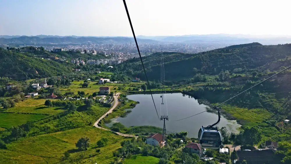
View from the cable car of the Dajiti to Tirana, Image: PaulSat / shutterstock
The metropolis, port and university city of Tirana also inspires with its location. Tirana’s local mountain Dajti rises in the east of the city and gives its name to the Dajti National Park. In the particularly charming mountain landscape, there are traces of prehistoric settlements, remains of numerous fortifications, deep river valleys and the surrounding mountains.
The mountain is also often referred to as the balcony of Tirana, because it offers a fabulously beautiful view of the capital of Albania, which lies at the foot of the mountain. If you don’t want to miss the view, but don’t feel like an arduous ascent, you can easily reach the local mountain from the eastern outskirts of Tirana by cable car. However, the summit of Dajti cannot be climbed, because it is still a military restricted area today. Summiteers can alternatively climb the Maje e Tujanit.
Around the turbulent capital there are also beautiful river valleys and idyllic lakes. Lake Tirana is very popular in the large park, which is located on the southern edge of the city center and was artificially created in 1956. However, Fakra Lake, Kashar Lake and Paskuqan Lake are also popular with locals and tourists.
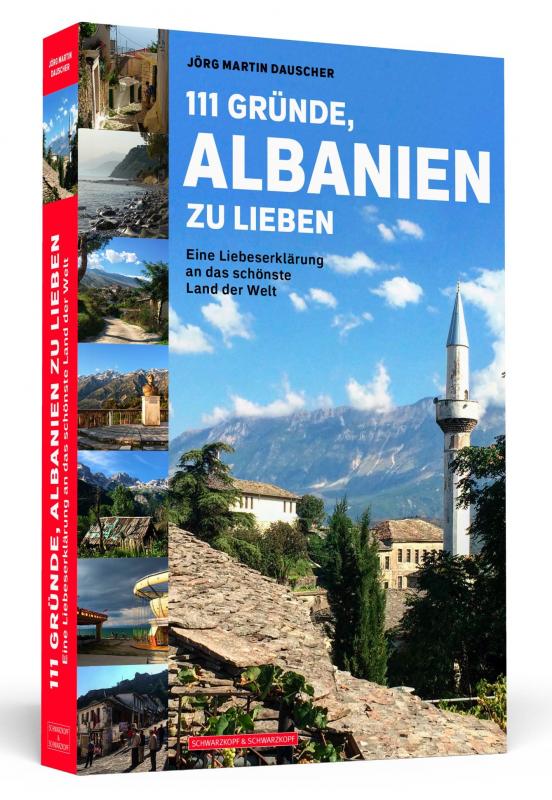
However, Albania has more to offer than just the capital Tirana. We therefore recommend Jörg Martin Dauscher’s declaration of love “111 reasons to love Albania”. Here you will find exciting and funny stories that are a pleasure to visit the Balkan country. It is best to order the book under the ISBN 978-3-86265-786-5 from your local bookseller
The sights of the charming port city of Tirana
Tirana is not only the political center of Albania, but also the cultural one. The area of today’s Tirana has been inhabited since the Paleolithic Age. Since then, today’s capital has experienced many ups and downs. Although the city has always played an important role thanks to its port, it was not until 1920 that it was designated as the capital. Today, Tirana is a big city and attracts visitors with the country’s largest museums, excellent art galleries and other cultural institutions such as the Palace of Culture, the State Opera and Ballet Theatre and the National Library. In particular, the National Historical Museum, the National Archaeological Museum and the National Art Gallery attract visitors from all over the world. But the botanical and zoological gardens of the metropolis are also extremely worth seeing. A visit to the Sky Tower is also a special experience, as there is a revolving restaurant here that offers a magnificent view of the city.
But there is also a lot to discover on a stroll through the city. Among other things, every visitor to Tirana should visit the equestrian statue in honor of Skanderbeg, a prince from the Albanian noble family of the Kastrioti. The equestrian statue can be found on the square of the same name. The prince became known for defending the Principality of Kastrioti against the Ottomans and is now considered an Albanian national hero who is revered throughout the country. Also worth seeing is the Et’hem Bey Mosque and, of course, the city’s landmark: a 35-metre-high tower built in 1830. Likewise, in Tirana there is the Monuemtal statue of the Mother of Albania, which every visitor to the city should have seen. Some stone arch bridges from the Ottoman period have also been preserved to this day, as well as castles and mosques. However, the most famous and impressive sight is the early Byzantine fortress Petrela. In addition, there are numerous city villas that are architecturally interesting and the Piramida, the pyramid-shaped building that once housed the Enver Hocha Museum. But in Tirana there are even the settlements, some of which were built illegally, with their prefabricated buildings, some of which were colorfully embellished by the artist and politician Edi Rama in a “painting action”.
Modern metropolis and forgotten traditions
Neighborhoods like Blloku stand for the modern and lively Tirana. This booming district is often referred to as the “playground of the young elite” and is characterised by boutiques, trendy restaurants, numerous cafés and bars. Tirana’s extreme growth in recent decades can be traced back to the rural exodus in Albania, as young people in particular are drawn to the capital to attend university and work here. While very old traditions are still maintained, especially in the mountain villages of Albania, they have long been forgotten in Tirana. Tirana has become a modern and cosmopolitan university city that offers excellent shopping opportunities, attractive cultural offerings and a varied nightlife. Albania’s capital presents itself as European and can certainly keep up with other metropolises.
The capital as a religious melting pot
The metropolis is also considered a religious melting pot, because the once Sunni-Islamic capital now has many inhabitants of other denominations and also many atheists who no longer belong to any religious community after the former communist rule. Tirana is the seat of the Grand Mufti of the Muslim community of Albania, but also the world centre of the Bektashi Order and the seat of the Catholic and Orthodox archbishops. A small Jewish community has also formed in the city and opened a synagogue, and communities of the Baha’i, the Ahmadiyya and the Jehovah’s Witnesses can also be found in the metropolis.
Culinary highlights in the capital
Albanian cuisine has a lot to offer, because it has been influenced by numerous nations and so Albanian cuisine is very Mediterranean and at the same time the oriental influences are unmistakable and the typical Balkan cuisine is also strongly represented. The Albanians are generally very hospitable and like to invite. Guests are more than well catered for here, as several dishes are usually served at once. The pita, which is prepared with a wide variety of fillings, is usually not to be missed.
But Trahana is also typical. Rice dishes with meat such as pilaf are just as much a part of Albanian cuisine as ayvar, cheese in all variations, flatbread and turshia (fried and then pickled vegetables). Soups and stews are also often served and there are also a wide variety of influences when it comes to desserts, as the spectrum ranges from baklava to pancakes. One of the most popular drinks is black tea, but mocha is also popular.
No matter where you go on holiday on the largest Canary Island Tenerife , excursions to the capital Santa Cruz de Tenerife and the port city of Puerto de la Cruz should definitely be on the excursion program. Santa Cruz can be easily reached from most major resorts in the north.
A stroll through the narrow streets of the old town is an absolute must. Sitting at the outdoor tables of the inviting bars, cafés and restaurants, watching the people strolling by and enjoying the sun – that’s pure holiday feeling! In the center of the oldest part of Santa Cruz is the church of Nuestra Señora de la Concepción with its tower visible from afar, and everywhere you can find picturesque buildings and remains from the colonial era.
If you like to go shopping, the best thing to do is to walk through the long pedestrian passage Calle Bethencourt Alfonso, which is also very attractive because of its large, shady trees. The typical Spanish market hall of Santa Cruz is popular with locals and tourists alike, because here you can not only buy fresh food, but also soak up the atmosphere with all your senses. A popular photo motif of the city is the auditorium at the harbor, which is reminiscent of the Sydney Opera House in its architecture. If you want, you can take a guided tour of the interiors. For plant lovers or holidaymakers who simply want to rest for a few minutes in a beautiful, green setting, we recommend the García Sañabria Park or the Botanical Garden.
The port city of Santa Cruz de Tenerife is probably one of the most beautiful places that the Canary Islands have to offer. With the historic city center, an impressive nightlife and a variety of cultural and gastronomic highlights, the city is a nice change from the rather quiet beaches of the island. Holidaymakers can not only look forward to a lot of sightseeing, great restaurants and a very special attitude to life, but of course also have the opportunity to travel to various other parts of the island and discover Tenerife.
One of the most beautiful cities in Spain on a beautiful island
View of Santa Cruz de Tenerife, Image: Balate Dorin / shutterstock
Along with Las Palmas de Gran Canaria , Santa Cruz de Tenerife is the capital of the Canary Islands region and has earned this title not only through the many destinations for tourists. After all, the city was founded in 1494 and was considered one of the first colonies that the Spaniards discovered during their mission to conquer the world. Since then, the Canary Islands have become an important intersection between the new and the old world, and the cultural influences that have flowed into the island from both sides have been correspondingly great, which can still be seen today.
The huge port, for example, is still a relic of the past and a focal point of life in the city. Above all, however, there are many historical buildings that have survived the centuries and give a small insight into the prosperity and importance of the Spanish colonial empire and what is left of it. This history is framed by a large number of green spaces that have been created in recent decades, making the city a bit of a small oasis. The contrast is a sight of its own, especially with the volcanic mountains in the background.
The main attractions in Santa Cruz de Tenerife
In general, you should have seen the carnival in Santa Cruz de Tenerife. It is considered an absolute highlight and one of the most beautiful of its kind in Spain – but of course it is also an attraction for tourists, who flock to the city at this time to experience it. Apart from that, the port city has no shortage of sights for the rest of the year, for which you should definitely plan more than one day to experience them completely.
Of course, you should have seen the old town if you decide to take a trip to Santa Cruz de Tenerife. This is where the first settlers of the island made their home and from here the city expanded in the decades that followed. With its squares, avenues and small alleys, the old town offers a lot of variety. In addition to the Plaza de España, which offers some of the best cafeterias in the city, you should also have been to the Plaza de la Iglesia. In particular, the monumental church of Nuestra Señora de la Concepción, which stands on the edge of the square, is considered one of the landmarks of the city and the entire island.
If you want to let the mixture of cultures work its magic on you, you should pay a visit to the Mercado de Nuestra Señora de África. The market hall is not only an important supplier for the many great restaurants in the city, but of course also offers private visitors the opportunity to buy exotic goods and fresh products. There are also many small snack bars and restaurants that shop directly at the market and can therefore score points with fresh food.
Recreation and excursions in Santa Cruz de Tenerife
It wouldn’t be one of the most important cities in Tenerife if you didn’t find a lot of relaxation here easily and quickly. The palm gardens of the city itself invite you to linger and offer the opportunity to slow down a bit and thus let the city have a stronger effect on you. Above all, however, it is the many beaches in the area that attract visitors and promise a day of swimming. Playa de Las Teresitas is probably the most popular beach and can be easily reached by public transport or taxi. A trip with your own car is not worthwhile, because the situation with the parking spaces only offers pure chaos.
If you don’t want to go to the other sights of the island, you should pay special attention to the city’s nightlife. Santa Cruz turns into a terrific mix of bars and restaurants at night and, typical for the Spaniards, it is only after sunset that life begins for the locals. In the tapas bars and clubs you get to know a whole new side of Tenerife and can prepare for great new memories from your holiday.
The most popular holiday resort in the north of Tenerife: Puerto de la Cruz
The most important sights of the tourist centre can be easily conquered on foot, as most of the attractions are located on or at least near the seafront. One of the highlights is of course the complex of seawater swimming pools “Lago Martiánez”, designed by the Canarian artist César Manrique. Since high waves and strong surf often occur on the coast of the northern part of the island, the fantastic complex between the Atlantic Ocean and the beach promenade was built in the 1970s.
Since then, it has been possible to swim safely in its differently designed pools in an extraordinary ambience. World-famous and visitor magnet number 1 on Tenerife is the Loro Park. Over the decades, the park, which originally specialised only in parrots, has developed into one of the most beautiful zoos and amusement parks in Europe, which is also famous for its dolphin and orca shows and has already won several awards. A day at Loro Park is an essential part of a successful stay on the island, especially for families.
But tourists interested in culture will not miss out in Puerto de la Cruz either, because everywhere there are beautifully restored historic buildings to see, which date back to past centuries and remind us of the history of this former fishing village. A great example is the church of Nuestra Señora de la Peña de Francia, which dates back to the 17th century. Despite the rather inconspicuous façade made of dark lava rock, its interior hides a unique splendour. For example, part of the main altar is made of pure gold and the side altars are hardly less impressive. Puerto de la Cruz is truly a place that has something for everyone and exudes a wonderful holiday atmosphere.
Information about Puerto de la Cruz
Puerto de la Cruz is a town in the valley of La Orotava, in the north of the island of Tenerife. The name of the city comes from English and translates as “port of the cross”. Due to the volcanic relief of the island, the city center is located at an altitude of about 249 meters. Puerto de la Cruz is one of the best holiday resorts in the Canary Islands. The old town is very nice. Much of the area around the old fishing port consists of narrow, cobbled streets with colonial architecture. Today, Puerto de la Cruz has a wide range of beautiful hotels to suit all tastes and budgets. In addition to the old-world charm, the town also offers some of the most interesting attractions for visitors to the island.
Puerto de la Cruz in the past and today
Puerto de la Cruz was founded in 1502 as a small fishing village with a port that served the nearby large town of La Orotava. Gradually, the port gained importance until 1706, when the island’s volcano erupted and destroyed the main port of the north, Garachico, making Puerto de la Cruz the most important and busiest port on the island. Gradually, the sugar trade was replaced by wine production and exports. The exports initiated by the European colonizers after the conquest in the 15th century led to large flows of trade and passengers to the island for decades, and so the first foreign visitors to the island were attracted by the unique climate and air quality of the Taoro Valley, where they were treated for various respiratory diseases.
In the middle of the 17th century, the inhabitants of the settlement asked King Felipe IV for royal permission to secede from La Orotava and found their own city. Thus, Puerto de la Cruz was declared a city on May 3, 1651 and was able to elect its own rulers.
At the beginning of the 19th century, a large part of the European elite was drawn to the islands. Some of the most famous visitors were the writer William Wilde and the German explorer, geographer and botanist Alexander von Humboldt, who came to Tenerife to study the extraordinary flora.
Mass tourism began to play a crucial role in the local economy at the end of the 19th century. At that time, the first Taoro Hotel was built, and many of the old family houses from the colonial era were converted into hotels. One of the first tourist booms took place in the 1950s, when the city became a major tourist destination, not only on the island of Tenerife, but throughout the archipelago.
Best things to do in Puerto de la Cruz
If you are staying in Puerto de la Cruz, be sure to visit the artificial beach Lago Martianez. The road passes Punta del Viento (Windy Point), which is located above the Rustico restaurant, with rooms in the rock directly on the sea. From here you have a breathtaking view of the beach of Lago Martianez. This is probably one of the most photographed landscapes of Puerto de la Cruz. The coast of Puerto de la Cruz is very rocky and cannot be used as a beach by tourists. The famous architect of Lanzarote, César Manrique, designed Lago Martianez in such a way that it harmonizes with the natural features of the area.
The beach includes several islands in an artificial lake, gardens, restaurants, bars, terraces and all this fits into the natural profile of the sea coast and forms a great place for a beach or simply to relax. The palm trees and the volcanic rocks contribute to the exoticism of Lake Martianez. Unfortunately, you can’t freely enter the beach to walk there. Admission is subject to a fee. If you don’t want to pay that, you can explore almost everything outside of Lago Martianez. There is no barrier wall. The beach is one level lower than the promenade, and the difference in height between the two acts like a barrier.
On land, in addition to the beach, there are luxury hotels with spectacular views of Lake Martianez and the sea. The restaurants of the hotels and the restaurants in front of the hotels offer a varied menu, including seafood and the obligatory sangría. It’s not just about wine. In addition to red wine, Sangría also contains rum, at least two types of liqueur, the juice of fruit compote and its fruits, and fresh orange pieces. Cold sangria on balmy Tenerife nights is simply a divine drink – it cools the body and invigorates the senses.
In the streets of Puerto de la Cruz, Tenerife
If you stroll along San Telmo Street, which is located by the sea, you will notice that the alley smells of freshly baked waffles. At the other end, there are restaurants that are hard to walk past without stopping to see what they offer. You can eat the famous cold tomato soup called gazpacho andaluz.
The city center or the Plaza del charco (Puddle Square) traditionally divides the central part of the city into two parts. The eastern one (towards Lago Martianez) is more luxurious and has more shopping opportunities. The western part is quieter, more serene and has a more pronounced romantic character. There are many restaurants that are open for dinner, and all are small, with a few tables and a family atmosphere. They offer incredibly tasty dishes, and since there are few customers, the chef only cares about you. The result is unique.
Incomparable flair in San Cristobal de La Laguna
La Laguna, as the place is usually called, is the former capital of Tenerife and is located in the northeast of the island. It impresses with a historic old town from the 16th century, which is on the UNESCO World Heritage List. Tourists interested in history and architecture in particular will get their money’s worth here, as a large number of old churches and city villas characterize the picture. During a walk through La Laguna, which is located at an altitude of about 600 m, the oldest church on the island, the Nuestra Señora de la Concepción, should definitely be on the program. The Museum of History and Anthropology, which is largely dedicated to the indigenous people, the Guanches, is also recommended not only for bad weather days.
San Christobal de La Laguna – the cool beauty among Tenerife’s cities
Nestled in the high valley of Aguere lies San Christobal de La Laguna. No other city in the Canary archipelago can boast as many churches, chapels, monasteries and hermitages as San Christobal de La Laguna. What are you waiting for? Tangible, tangible history invites you to take a walk into the past.
Founded in 1496 near a small lake that has now disappeared, San Christobal de La Laguna was not only the capital of Tenerife, but of the entire archipelago. As a residential and administrative city, La Laguna attracted intellectual and spiritual life. The military had its headquarters here, as did the bishop and various monastic orders, which enriched the cityscape with handsome churches and monasteries.
Today, the city with over 150,000 inhabitants is the seat of the most important university in the Canary Islands, among other things.
On the shortest route to La Laguna: A tram connects the new island metropolis of Santa Cruz with the old capital San Christobal de La Laguna. In 1833, Santa Cruz replaced La Laguna as the island’s capital. To this day, San Christobal de La Laguna presents itself like an open history book. More than 40 historic buildings in the old town are designated as UNESCO World Heritage Sites. As soon as the Guanches were subdued, the Spanish conquistadors began to build a colonial city, which was to be groundbreaking for the founding of cities in the New World.
The UNESCO-ennobled colonial splendor is best discovered in a morning – ideally on a Thursday or Saturday, when all the museums and monasteries are open. Tip for a first impression: From the tower of the Concépsion Church you have a great view over the World Heritage City.
Let’s move on! San Christobal de La Laguna inspires with colorful student hustle and bustle and a charming old town. Churches, monasteries, museums, restaurants and wine bars – La Laguna surprises with an extraordinary diversity. Most of the central streets are traffic-calmed, the facades painted pastel and the romantic courtyards restored. The Plaza de Cristo with the adjoining Parque de la Constitucion in the east of the city is an atmospheric prelude to a city tour.
Others start their tour at the Plaza del Adelantado. The crowns of the palm trees, laurel and dragon trees form such a dense roof over the square that hardly a ray of light penetrates the ground. The square, named after the “adelantado”, the “leader”, is flanked on all sides by monasteries and stately residences.
Stroll zone with flair
A stroll through Calle Heradores, recently converted into a pedestrian mile, introduces you to the carefully restored heritage of the old capital. Many pretty details can be discovered: tiny wrought-iron standing balconies, massive brass door knockers or the coat of arms of a family clan above the lintel. In some places, a fountain splashes in green courtyards, such as in the almost 400-year-old Casa Alvarado Bracamonte, from which the captains general once steered the fate of the island with an iron hand.
One of the oldest buildings is the house of the bailiff near the central Plaza del Adelantado. On the square with an old dragon tree, the classicist town hall and the St. Catherine’s monastery, adorned with a Moorish-looking balcony, are among the most striking buildings.
A visit to the Casa de Lercaro, which is furnished with magnificent woodwork, rounds off the journey through time, fittingly housed the Museum of the Island’s History.
Despite history on every corner, La Laguna is a young city. This is mainly due to the university, which was founded in 1792 and today has around 24,000 students.
Short break
The tapas bars at the Plaza de la Conepción are very popular, where Café Palmelita also invites you to coffee and cake. The square in front of the church with its pretty street cafés is an ideal place to let the historical flair work its magic on you in a deeply relaxed way.
Hiking paradise and beach fun – the surroundings are wonderful
The way can hardly be long enough for lovers: Not only couples enjoy a walk along the palm-lined Avenida Paseo de las Palmas.
But La Laguna is also a hiker’s paradise: From the city, a road winds up to the Bosque de la Mercedes in the Anaga Mountains. However, the peninsula in the far northeast only shows itself in the best light to early risers. Around noon at the latest, milky wafts of mist usually envelop the mountains in a dense cotton pack. On a clear day, the Pico del Inglés viewpoint, which is almost 1,000 metres above sea level, offers a great view of the Anaga Mountains.
A hike to the cave dwellings in Chinamada, lined with geraniums, which unfold a beguiling colourfulness under a bright blue sky, is also popular. Meanwhile, Playa de las Teresitas near San Andrés satisfies the longing for sun and sea.
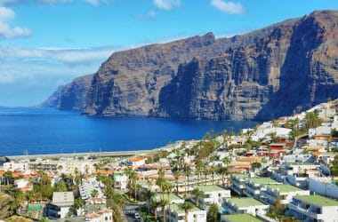
From fishing village to tourist hotspot – Los Gigantes
Los Gigantes, Image: Marisa Estivill / shutterstock
Nature lovers and active holidaymakers in particular will be delighted by a stay in Acantilados de Los Gigantes (Rock Face of the Giants) in the west of Tenerife. The district of the municipality of Santiago del Teide has become a popular destination due to its fantastic coastal landscape. The vertical rock walls extend over a length of more than nine kilometres, reaching a height of up to 500 m and are therefore considered the second highest in Europe. Various viewpoints each offer fantastic views, but on one of the boat tours on offer you can experience the cliffs from an even more impressive perspective. Trips to observe dolphins and pilot whales also start here. The underwater world is a paradise for divers and snorkelers and bathing tourists love the nearby Playa de los Guios, which scores with its black volcanic sand. Los Gigantes offers more than 300 days of sunshine a year and a decidedly mild climate – a perfect starting point for hikes in the Teide National Park and through the Teno Mountains.
Costa Adeje – ideal for a comfortable beach holiday
Costa Adeje, Image: Nanisimova / shutterstock
Costa Adeje is located in the southwest of Tenerife and is ideal for tourists who want to spend a classic beach holiday and value a first-class infrastructure. On the well-kept beach promenade you will find fine restaurants as well as tasteful shops and the surrounding area offers some of the most beautiful beaches on the island.
The Costa Adeje is a comparatively little-discovered section of the popular island of the Canary Islands. The city of the same name for the region is almost a bit sleepy compared to the big tourist strongholds, which offers a charm of its own for travelers who get lost in this direction. Costa Adeje has just as many sights to offer, especially with regard to nature, as many other parts of the island. In addition to its own sights, the way to the rest of the island is of course still free, which can be easily reached from here, especially with your own car.
Luxury and special enclaves – the retreat in Tenerife
Over the years, Costa Adeje has gained a reputation for being particularly exclusive and offering a special luxury in both shops and hotels. Here, the focus is on particularly high-quality but also expensive accommodation, and in the city’s shops, high-quality brands are not uncommon for holidaymakers. It is also important to know that the name does not only refer to the small town, but to the entire section of the coast in this area of the island. This leads to confusion from time to time.
The distinction between town and coast is important because the region was created only a few decades ago and does not have a historical heritage, as is the case with Santa Cruz de Tenerife, for example. Instead, you have to deal with an interesting tourist infrastructure that is a bit more designed for rest and relaxation than for sightseeing and adventure. Especially those who are looking for a few quiet days and weeks will get their money’s worth in Costa Adeje – which is also due to the many good accommodations.
If you are looking for historical sites in Tenerife, you will find them especially in the city of Adeje, the namesake of the region. Unlike the tourist resorts, the focus here is mainly on the preservation of the various historical buildings and offers hikers, cyclists and accompanied tours an interesting insight into the history of the island.
The main attractions when visiting Costa Adeje
A trip to historic Adeje should definitely be done when visiting the region. Whether it’s historical places like the church of Santa Úrsula or the various historic housing complexes, here you can get a good view of how the first settlers lived on the island and what architecture they used. Most hotels in the holiday region offer corresponding tours, but you will also get to the village quite quickly and easily by bike or rental car.
Of course, you have the opportunity to see the many other sights of the island. However, since Costa Adeje is a fairly new area, there are no classic historical sights here. Instead, the focus has been on a comprehensive range of leisure and relaxation activities and offers a wide variety of options in this area. Therefore, a trip to Santa Cruz de Tenerife, which can be reached in a few hours, can satisfy the hunger for historical sights. In general, a trip to the city is recommended from any point in Tenerife, because the city has a very special magic.
Tranquillity, recreation, food and nightlife in Costa Adeje
Those who decide to spend their holidays on the Costa Adeje want above all to enjoy life and the island itself. So it’s no wonder that the region has adapted to these holidaymakers in particular. Restaurants, cafes and bars can be found everywhere and there are also snack bars and the right places for snacks on the many beaches. Water sports play a role and the beaches offer not only sun and sand, but also a wide variety of activities for the long day. The hotels, for example, have interesting offers in the field of massages and treatments at the spas and are therefore interesting alternatives for a long day at the sea.
In the evening, the trip to Costa Adeje is all the more worthwhile. The nightlife here has developed in a very short time and offers not only clubs and bars, but also theatres and events that are interesting and can give a special touch to the holiday
For some, this is a country before our era. It is the realm of the pyramids and the pharaohs, and the stone witnesses of the past leave the viewer amazed and incredulous. Egypt – these are wonders of the world that you can touch and that you must have seen, because they are unique in the world and where the larger-than-life statues in the temple in Luxor proclaim power and domination. This country on the Nile is two things: blessed with mysterious tombs and a retreat on the beaches of the Red Sea to unwind.
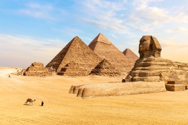
The Pyramids of Giza, Image: AlexAnton / shutterstock
The Egyptians like to speak of their country as the “Mother of the World”. It is certainly a land between heaven and earth. Between the biblical sites on the Sinai peninsula and the colossal tombs that were snatched from the sand sea on the great river and have encouraged conservators to race against transience for decades. The realm of the dead is a fascinating example of people’s delusion of securing a place for eternity. The pyramids of the god-kings in Giza are among the most interesting travel destinations on our globe.
Anyone who visits Egypt embarks on a journey through 7,000 years of history and to the temples of the cult of the dead. Most holidaymakers land in the lively capital Cairo and then either head southeast to the warm waves of the Red Sea or approach Luxor, the Valley of the Kings or the Hatshepsut Temple in the form of a Nile cruise. More than three hundred ships are sailing on the Nile to transport holidaymakers to the sites where the pharaohs dreamed of immortality and afforded themselves the luxury of gigantic buildings.
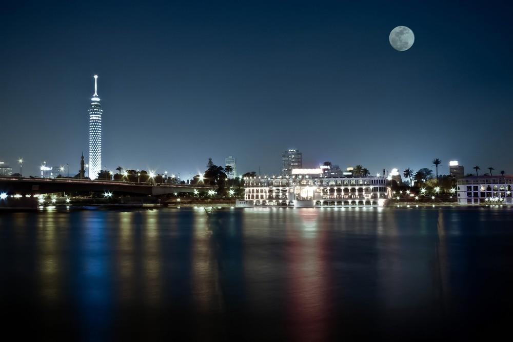
The capital Cairo at night, Image: Kazzazm / shutterstock
The pyramids still pose puzzles not only to the observer but also to scientists, and it is inconceivable that all this was created by human hands in an era when no one dared to dream of a technical revolution. Hieroglyphics of that time show that even the downtrodden people were convinced that the rulers reached the “land of light” after their death via a kind of ladder to heaven. Many holidaymakers stand humbly in front of these wonders in the Orient.
The trips with a ship of the Nile fleet, which usually start in Luxor , are pleasant. On the shore, the mud huts of the villages glide past here and there, or the contours of a minaret. And behind it, the desert spreads out – golden yellow and mysterious. Egypt has many faces, and if you want to understand the history of the country, you should also take a look around Cairo’s large museums.
On the Red Sea, some first-class or futuristic art cities have emerged. For example, the seaside resort of El-Gouna, where artificial islands, hills and lagoons have been built and where holidaymakers can choose between Venetian, Nubian or Yemeni domiciles. Here, the imagination of world-famous landscape architects and urban planners has been lived out and created amazing things. But also in Hurghada , 22 kilometers away, there are a number of modern hotels with huge water landscapes and challenging golf courses.
The magic of the Red Sea is also revealed under water. The areas are a highlight for divers, and the shipwrecks off the coast are teeming with schools of damselfish. This is the warmest sea that can be reached from Europe and an Eldorado for water sports enthusiasts.
Snow-covered treetops glistening in the sun and sparkling light between wintry branches: this is the picture you can see in the Sonnenwald ski area. Here a winter fairy tale becomes reality. A radiant mood and a satisfied smile when you fall into bed tired in the evening: the Sonnenwald lives up to its name!
This destination is one for everyone: in this ski area you can let off steam and discover a lot. Skiing for the whole family – the Sonnenwald ski area in the middle of the Bavarian Forest is a special destination for all those who really want to experience something. Here everyone enjoys an uncomplicated holiday with extra variety. Various slopes and ski lifts guarantee skiing fun for all levels. If skiing is not the focus, then there are also a lot of other activities in the Sonnenwald that young and old can pursue.
The most famous mountain in the Sonnenwald ski area is the Brotjacklriegel, also a popular destination in summer. There has been an observation tower on its summit since 1925, which offers breathtaking views over Bavaria. At the Brotjacklriegel there is a varied ski area with many great offers for the whole family.
Baby lifts, toboggan runs or fun parks bring variety to everyday winter life. There is a story about the funny name of this mountain. Supposedly, a bearded little man sought refuge on the mountain during the Swedish War. His name was Jackl and he always had enough bread to eat in front of his cave. Because he did not reveal the secret of his almost inexhaustible supply of bread to the Swedes , they rolled a boulder in front of his cave out of sheer anger. There was a thunderclap and the Swedes were turned into boulders. These are still on the mountain today…
Another, admittedly not quite as spectacular story, says that the mountain was actually called Breiter Jägerriegel and this name was transformed into “Brotjacklriegel” over time with the help of the dialect.
Up and down again
The bread jack bar, Image: lantapix / shutterstock
Still wobbly on the skis or already safely down the long descent? The various lifts in the Sonnenwald ski area together form a sophisticated concept in which everyone gets their money’s worth. It also has the longest conveyor belt in the entire Bavarian Forest. This allows the youngest ski talents to practice diligently. No one has to practice alone here, because in the Sonnenwald ski area the professionals from the ski school are ready.
The next level is at the Steinberg lift, because if you have practiced well enough, you can have fun here. Practice wild jumps: once through the fun park is not enough! But skiing is not everything. If you want to enjoy the winter fun to the fullest, you have a lot of other options here. In addition to the slope, there is also a toboggan run that tempts you to take fun sleigh rides. By the way, this is not only possible in daylight. Thanks to floodlights, the fun continues even in the dark. When the day comes to an end and the sun goes down, the winter fun is far from over! The lifts have very long opening hours and also good prices. In order to be able to offer families with several children great days of skiing, there are special family tickets here.
Fun off the slopes
Although the Sonnenwald ski area is not primarily famous for its Aires skiing opportunities, there are a few opportunities to have fun off-piste as well. In this ski area there are a few good places to stop for refreshments not far from skiing fun. And who serves the guests in the Yeti Hut remains a well-kept secret that requires a visit on the spot to find out! If you want to continue the sporting fun, but don’t want to ski every day, you can try cross-country skiing. In addition to the ski slopes in the Sonnenwald, there are also great cross-country trails to explore.
An exploration tour in the Bavarian Forest
So it is very worthwhile to discover the Sonnenwald ski area. The small winter paradise, hidden between ancient tree trunks and sunny slopes, is more than just an insider tip. Whether as a family, as a couple or alone – here it is easy to feel comfortable, to live out your sports and to experience special days that will be remembered forever. The paths in the ski area are short and practical, so you can spend your free time comfortably and don’t have to worry much about the daily routine. The Sonnenwald ski area shows winter at its best – with all the possibilities this season has to offer!