


The SSS Islands are a group of three islands in the Lesser Antilles in the Caribbean. They belong to the territory of the Netherlands and are among the “Leeward Islands” in the Caribbean.
The two islands of Sint Eustatius and Saba have the status of a “Special Municipality of the Country of the Netherlands”. In addition, there is the Dutch part of the island of St. Martin: Sint Maarten is an autonomous country within the Kingdom of the Netherlands.
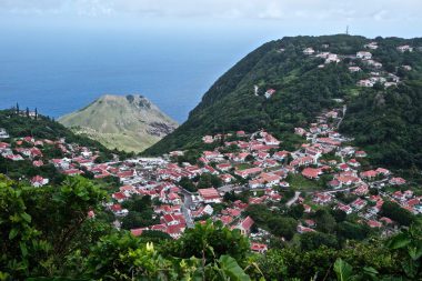
Sint Eustatius
On the island of Sint Eustatius live about 3142 inhabitants on an area of 21 km².
The island has been a Dutch colony since 1816. Since 10 October 2010, the island has been part of the Netherlands as a “Special Municipality”.
In the 18th century, the island was very prosperous through trade. However, the end of the slave trade, the supremacy of the now independent USA in transatlantic trade and the French occupation of Sint Eustatius in 1795 brought the economic heyday of the island to an end.
The official language is Dutch, but the English language dominates everyday life. As an overseas territory, the island is not only part of the European Union. Therefore, the currency is not the euro, but the US dollar. The capital of the island is Oranjestad.
The island owes its formation to volcanic activity. The almost 600m high volcano “The Quill” is now a dormant stratovolcano. Nevertheless, the volcano is still active today, as evidenced by temperature measurements in the groundwater of the volcano. Its crater attracts many tourists.
Sint Eustatius has tropical temperatures. Hurricanes are possible in the months of August to October.
The island has an airport and a port for ferries. Cruise ships cannot call at the port. Your guests will be taken to the island by tender boats. Worth seeing are the Quill/Boven National Park, the Fort de Windt and the St Eustatius Historical Foundation Museum.
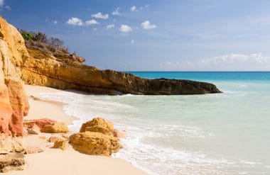
Saba
The island of “Saba” is also a special municipality of the country of the Netherlands. The floor area of Saba is only 13 km². As of January 2021, 1918 inhabitants were registered on the island.
The capital of Saba is “The Bottom”. As in Sint Eustatius, Dutch is the official language in Saba. Everyday life is dominated by the English language. The currency is the US dollar.
Saba has no natural beaches. The island is surrounded by cliffs. Geologically, Saba is one of the young islands. It was formed by volcanic activity during the last 500,000 years. The volcano “Mount Scenery” occupies large parts of the island’s area. It is 877 meters high and is one of the dormant volcanoes. The last eruption is dated to 1640. Curiously, the volcano is the highest elevation in the entire Kingdom of the Netherlands.
Climatically, Saba is also one of the tropics. Cool trade winds from the northeast make the temperatures a little more bearable.
In colonial times, the rainforest was completely cut down. Today, however, there is again a very diverse secondary rainforest on the island, through which numerous hiking trails lead. Since there are no poisonous or dangerous animals on Saba, a hike through the rainforest is highly recommended.
However, you have to expect many mosquitoes, especially in the rainy season.
A hiking trail also leads through the rainforest to the summit of Mount Scenery.
Divers will find good conditions in the sea off Saba. The underwater world is protected by strict regulations and laws.
900 steep rock steps lead from the capital down the cliffs to Ladder Bay. Until the 2nd half of the 20th century, the island could only be entered via this arduous path. All goods and commodities also had to be transported on this route. Since 1960, Saba has had a small airport with an extremely short runway. A longer runway was not possible, as the airport was already being built on the only possible level of the island.
The most important economic sector today is tourism. Saba is very popular with divers. The island even has 4 decompression chambers for exchange accidents.
Sint Maarten
Sint Maarten is the southern part of the Caribbean island of St. Martin. The northern part belongs to France. It is an autonomous country that belongs to the Netherlands. Accordingly, the Dutch King Willem-Alexander is also the head of state of Sint Maarten. About 40,614 people live on an area of 34km².
A good 65% of the population are Dutch. They are descendants of Dutch settlers. Almost 75% of the population belong to the Christian faith. The capital of Sint Maarten is Philipsburg. The official languages are English and Dutch.
Sint Maarten is a tax haven. The companies that are registered on the island but do not do business in the Dutch part do not have to pay tax. VAT is only 5%.
Sint Maarten is often visited by cruise ships. The free port allows guests to shop tax- and duty-free. They therefore like to use their stay in Sint Maarten to buy tobacco products and spirits at low prices.
Sint Maarten is also famous for its airport. The runway is located directly on the beach and the planes fly directly over the heads of the bathers.
For example, it is possible to stand directly under an aircraft and photograph it from below. This is not entirely without danger, and so there are also warnings on the section of beach that is open to tourists.